Boating dangers of Boston Harbor: Updated for the 2013 Season with photos!
Boston Harbor can pose many dangers to boaters. Below I have posted a list of the place that are, in my opinion as an experienced Boston Harbor mariner, the most dangerous places to navigate in the Harbor. Boaters should seek to familiarize themselves with these areas, and then use caution to avoid them. I have pasted these NOAA chart clips in here for reference- they are not for official navigation, but should be helpful in knowing the main dangers of the harbor and their locations. Boston Harbor Beacon hopes you have a safe boating season!
1) Lower Middle and Castle Island flats. These are flat, rocky areas right around the channel between Castle Island and the airport. Don’t forget, what is now Logan Airport used to be Governor’s Island and its surrounding shoals. Don’t cut the green can right of Castle Island, and don’t forget to be observant of the split in the channel around Lower Middle as you navigate through this area. Below is a photo of the Castle Island flats at low tide, visible to the left of the green can just outside the channel:

The chart of Lower Middle and the Castle Island Flats:

2) South channel off president roads. The green buoys on the south side of the south channel must be observed carefully, as dangers lie just beyond. These include the Ram’s head flats, Aldridge Ledge, and the infamous Devil’s Back. This area is so tricky that even a professional whale watch operator hit the Devil’s Back two summers ago. As you head out the south channel and pass buoy #7, it may appear as though you are in the clear- but don’t be fooled. Keep inside the channel until the very end. Below is a photo of the Devils Back at low tide- in an open area that feels deceptively safe and clear. At mid or high tide, the breaking waves are even less visible so the area is even more deadly:

The chart of President Roads and the South Channel:

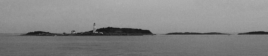
3) Graves light and the roaring bulls. This spooky old lighthouse is no longer in service, but it was place here for a reason. Graves sits about a mile NE of the mouth of Nantasket Roads as they open into the ocean, and is surrounded by obstacles- particularly the roaring bulls- two large rocks that lurk just under the surface in anything but low tide, and the Graves Ledge, which extends a good 500 yards off the NE corner of the light. This is well labeled by a green can, but can be perplexing when approaching from the south. While Grave’s Ledge is market adequately with a green can, The roaring bulls are not marked, and are very dangerous to anyone using the Hypocrite Channel. Below are the roaring bulls at low tide, with Graves in the background:

The chart of Graves light and the Roaring Bulls:

4) Half tide rock. This is basically a big rock/ledge just west of Hypocrite Channel. While well marked, it can be tricky given its position in an otherwise wide open place. It becomes especially tricky from half tide to full tide (as the name would suggest) as it is not visible from the surface. Below is a low tide view of the Halftide Rocks, well marked with a red nun, but not visible at mid or high tide. Note Green Island and Graves Light in the background:

The chart of Halftide Rock, note the red nun positioned to the West of Hypocrite Channel:

5) Great Fawn. This is a large flat and rock outcrop just East of Deer Island. The area is known for good fishing, but watch out not to get too close. Also, don’t cut inside the nearby Deer Island light and bell tower- there are nasty rocks in there. Here is a good perspective of the Great Fawn from Deer Island:

The Chart of Great Fawn:

6) Quarantine Rocks and Sunken Ledge. These are ledges in Quincy Bay, which are well marked, but difficult to avoid as they cover a wide open area where is is tough to tell whether one is coming or going and should therefore observe green or red. Below is a photo of the red beacon marking the Sunken Ledge in Quincy Bay:

The chart of the Sunken Ledge and Quarantine Rocks:

7) Sculpin Ledge. This is a little ledge off the Southeast side of Spectacle Island, which is heavily travelled, but not well marked. As the legend goes, its a good place to fish for sculpin, but I have never caught one here. Sculpin is not visible at just about any tide, which makes it very dangerous. I know of several boaters that have run aground in this deceptively open and clear area. Below is a photo of a sailboat near Sculpin Ledge, with Long Island in the background:

The chart of Sculpin Ledge, between Spectacle Island and Long Island:

8) Brewster Island Spit. This can be truly deadly at high tide, as this great spit occupies the seemingly open area between Brewster Island and Lovell’s. It is very easy to drive right over and ground your boat if you aren’t paying attention. I have a picture of a boat with a couple of guys who marooned themselves here few summers ago, but don’t want to embarrass them by posting it. Here is a photo of the Brewster Island Spit, extending all the way from Great Brewster (on the left) to the rocks in the foreground. The spit is generally not visible at high tide, making is particularly dangerous:

The Chart of The Great Brewster Spit (in green, middle of the clip):

9) Nix’s Mate. I couldn’t forget this one. While well marked, this area of barely submerged rock in the center of the outer harbor is deceptive. Located in an are between Long Island, Lovells, and Gallops, this area gets heavy shipping and recreational traffic. The area to avoid is marked by a black and white cone, with the channel to the right:

A chart of Nix’s Mate and the surrounding area:

See Disclaimer about Chart Clips below:


Pingback: Sunset Cruise out of Nantasket Roads out to Harding LedgeBoston Harbor Beacon
Pingback: Avoiding rocks….a key boating safety tip | | Boston Harbor BeaconBoston Harbor Beacon
Excellent summary. Especially description of Sculping ledge. We hit something there near R8A at low tide. Very deceptive area.
Thanks