My buddy Captain Jack asked me if I wanted to come along for a ride down to Cape Cod on his boat today. I replied “of course!” However, I was surprised when he suggested taking the Eastern route- around the outer bank of Cape Cod instead of going through the canal. We checked the wind and weather forecast, and last night decided to go for it! The trip took us around the Eastern side of Cape Cod’s National Seashore and right into Nantucket Sound via the Eastern Entrance.

We pulled out of Marina Bay in Quincy at 7:05 this morning. The full trip was 4 hours and 15 minutes to the final destination, which was Bass River in Yarmouth, MA.
I would highly recommend this trip, especially if you are heading somewhere on the Eastern Cape or Nantucket Sound. You will need to pick a calm day, as it could probably get quite miserable if the wind picks up. Boaters need to be prepared for the long stretch around the outer cape- there is nowhere to hide if the weather turns ugly. We were in a 25 ft center console with twin 150HP engines, which was very comfortable on a calm day with reported seas of 2-3ft (in reality, probably less). We averaged about 22 knots the entire trip.
Here is the Chronology of the trip:
7:05 AM: Depart Quincy, MA.

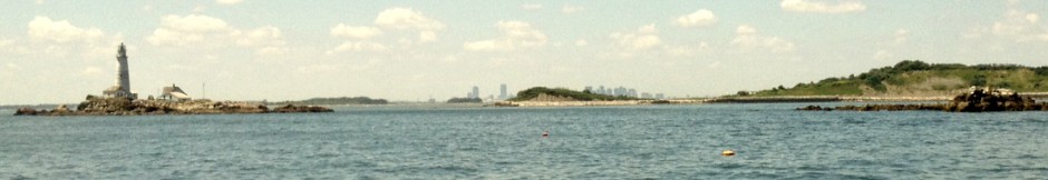
7:30 AM: Pass Boston Light and round Allerton Point in Hull. Relieved to find that the seas are calm and the wind is minimal. Make a direct heading for Minot Light, while navigating around Hardings Ledge.

7:50 AM: Pass Minot Light. Start to bear East, while observing onshore landmarks, including the Lawson Tower and the Scituate wind turbine.

8:10AM: First view of Standish Monument at Provincetown in the distance across the vast tranquil expanse of Cape Cod Bay. We kept an eye out for whales.

9:05 AM: Closing in on Race point, and making a bearing to the East to start our trip along the outer coast of the Cape. Note the Standish Monument at Provincetown provides a great reference point. Viewing the compass and GPS at this point is critical, as South and East can easily be confused given the diagonal running shoreline direction. There is some churning current near Race Point, but overall seas remain quite calm.

9:25 AM: Passing Truro/Wellfleet area. From about a half mile offshore, the sand dunes are very visible and reach several hundred feet high. There are very calm seas without much boat traffic in this area.

9:50: Passing Nauset Light. Good to see signs of civilization after a very isolated stretch.

10:20 AM: Passing by Chatham Harbor. The large red and white checker-board water towers became visible about 15 minutes beforehand.

10:45AM: Passing directly South of Monomoy Island. Great Point light on Nantucket is not visible today, as hard as I focus on the distance. It should be on a clearer day, as I have seen the Chatham water towers from the bluffs of Sconset on Nantucket on a very clear day. The water Northeast of Monomoy is very calm, but it quickly becomes choppy once you get to the South of the island and enter into Nantucket Sound.

11:05 AM: The four hour mark. Rounding the #2 nun in Nantucket Sound. The chop has picked up significantly in the bay versus out in the ocean where it was quite calm. This must be due to the Southeast wind, although it is not blowing much more than 10kts. There are some shoals in this area, but I did not observe every marker, because it was close to high tide.

11:20 AM: Pulling into Bass River from Nantucket Sound. Trip complete in 4 hours and 15 minutes. What a great way to see the coast of Cape Cod!


