A view from the hilltop trails of Deer Island, which are deceptively high and provide sweeping views of the Boston Harbor and city skyline:

Deer Island, lying at the end of Winthrop’s Point Shirley peninsula, is the outermost point of Boston Harbor’s northern shoreline. Much Like Castle Island, Deer Island is actually a peninsula, as a road was placed across the Shirley Gut, the narrow body of water which once separated this former island from the mainland. As such, this is one of the few islands not requiring a boat to access.
Deer Island has been used in the past as a prison, a quarantine station and a military fort. Today, Deer Island may be most famous for its water treatment plant, which has done wonders for improving the water quality of the harbor. However, there is a large part of the island unencumbered by the plant, and this part has been converted into a large public park, thanks to the folks at the MWRA.
The size of Deer Island-in both the height of its bluffs and the circumference of its waterfront-is deceptively large: much more so than it appears when viewed from the water. As the outermost island on the North shore of Boston Harbor, Deer Island offers unobstructed views of the ocean and the Boston Harbor Islands. Visiting on a bright winter day provides particlarly gorgeous view: The light brown winter straw grass blowing in the wind and reflecting the sun’s light makes a bright contrast against the deep blue January sky. Below is a view looking North, towards the North Shore:

A boater’s view of Deer Island:
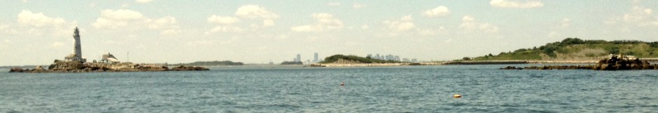
Deer Island as it appears from the water, with a view of the water treatment plant and wind turbines on the Southern end of the peninsula. Also visible is Deer Island light, that small object in the right foreground warning shipping traffic to steer clear of the rocks:

A nautical chart depicting Deer Island. Deer Island light is located at the Southern end of the Peninsula and the the East is the nearby Boston North channel and the Great Fawn. The latter is one of the major boating dangers of Boston Harbor (more on this below):

Clip from NOAA Nautical Chart. Not for official navigational purposes. See disclaimer at NOAA.com
Deer Island’s Treatment Plant:
A sweeping view of Deer Island’s water treatment plant, which occupies most of the island. Built in the early 1990s, this plant has been highly effective at improving the water quality of Boston Harbor and insuring that sewage would not end up in the water. Recall that before this plant was built, Boston Harbor was ranked as one of the dirtiest harbors in the country. Following a series of incidents in which raw sewage was released into Boston Harbor waters, federal judge Mazzone ordered this facility to be constructed in 1985, making it the second largest such facility in the world. It was a major undertaking to clean up the nation’s dirtiest harbor, one that would cost multiple billions of dollars and take years of engineering investment and implementation. But the most permanent cost of the project was that its construction tragically claimed several lives, in both the construction phase of the plant and the opening of the outfall tunnel.

A view of one of the egg-shaped towers up close. Thanks to the construction of the new park, one can walk all the way around the perimeter of the plant, down to the southern tip of the island where the tanks are located. While walking along the southern side of the island, one can see the massive concrete seawall that was built to protect the exposed eastern shore of the island during a storm.

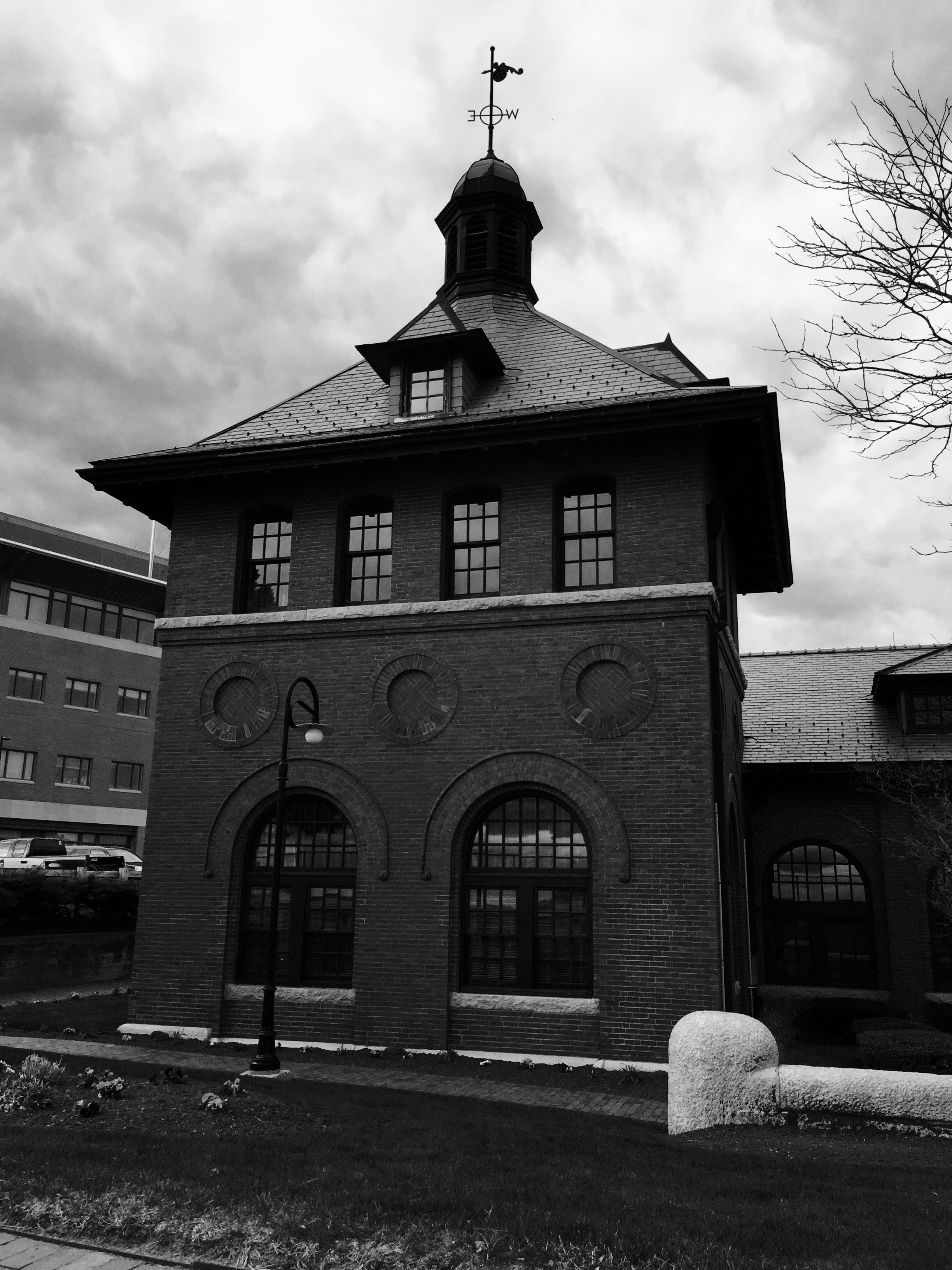
Prior to the large modern treatment plant, Deer Island was home to a the sewage treatment system of the last century. In 1899, a pump house was constructed on the island, and the historic pump house and its actual pump remain today, preserved by the MWRA. Operated up until 1968, the historic pumping station served fourteen municipalities around the Boston area and discharged untreated wastewater directly into the water. The historic pump house:
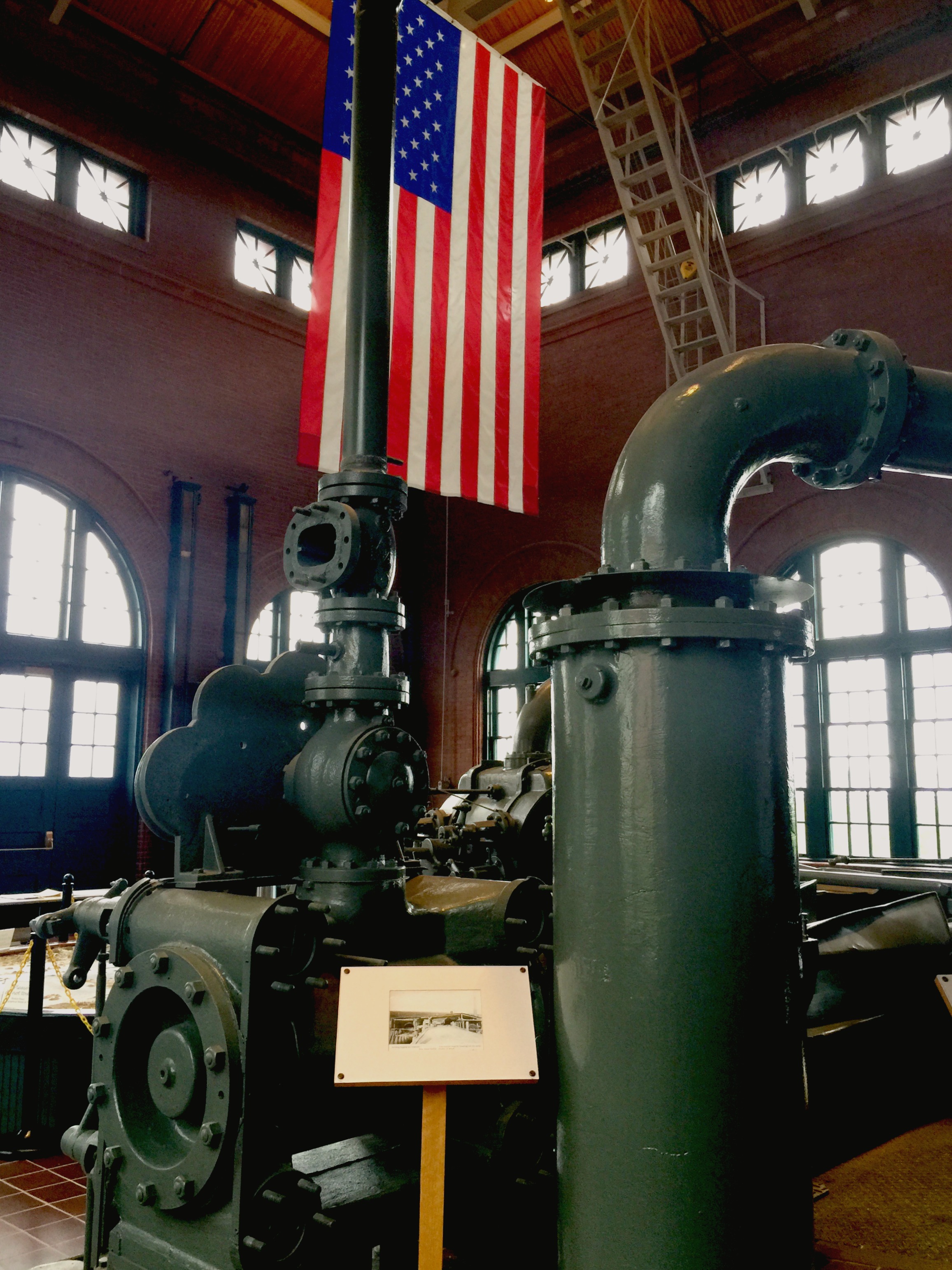
The actual pump mechanism itself, which has been restored and is on display:
Military History: Like most of the other islands, Deer Island was once occupied by a military fortification during the earlier parts of the 20th centuries. Fort Dawes guarded the harbor from Deer Island, and was the largest of the Boston Harbor military forts, which was logical given Deer Island’s long North-to-South exposure near the Harbor’s entrance. The fort was demolished in the 1980’s to accommodate the plant, and there are some great photos of the demolition process here. Today, all that remains of Fort Dawes is this small section of concrete wall from one of the battery casemates:

Today the island is powered by multiple types of renewable energy sources, including solar panels and at least three different types of wind generation structures. Here in the picture below, a strange wind turbine sits atop one of the hills:

Harbor Views from Deer Island:
Deer Island offers an unobstructed view of the outer Harbor islands. Here one can see The Brewsters: The dunes of Great Brewster Island in the center, and Boston Light on little Brewster island to the right. These islands lie approximately three miles East of Deer Island:

With it being close to low tide, the Great Fawn, one of the top boating dangers of Boston Harbor, was clearly visible. This is a good reminder to steer clear of this area:

A view to the Southeast, with the harbor and city skyline in view. Deer Island’s yellow grass hills and dark pines provide a nice contrast to the blue sky and green harbor water:
To the north lies Point Shirley and the Town of Winthrop. Locted near what is today the public parking lot at Deer Island, Shirley Gut was the narrow body of water that once ran between Winthrop and Deer Island, making it actually a true island. While the gut was narrow, it was often used in colonial times to circumvent the British Blockade of the harbor, as the legends go. The great hurricane of 1938 put an end to Shirley Gut: The storm’s powerful winds and waves shifted sands to an extent that the gut was filled in, and Deer Island was no longer a true island, but a peninsula.

The former Shirley Gut as seen from high atop the North drumlin of Spectacle Island. The small stretch of land right above where the ferry is in the picture is where the gut existed until it was closed during the storm of 1938:


