Across West Gut from Peddocks Island lies Nut Island, which extends into Quincy Bay. West Gut is a body of water not narrow enough to typically cause a significant torrent as tides ebb and flow. But when a southwest wind picks up against an incoming tide on a summer afternoon tumultuous sea of white caps often ensues as the current rounds Nut Island and Peddocks on its way in from the sea. Through the years, Nut Island has seen many ships in transit to the port of Fore River cutting through fair weather southwesterly winds and strong bay currents.

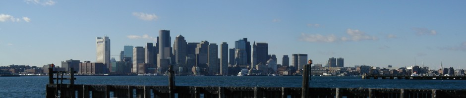
Once a testing ground for artillery and later the site of a sewage treatment plant, Nut Island may not have historically been the best known place to observe the natural beauty of Boston Harbor. However, today this protruding land mass, no longer actually an island, is lined with walking trails offering great views of Quincy Bay, the Boston Harbor Islands and the Boston City Skyline. Nut Island extends gracefully from Hough’s Neck in East Quincy into the southern end of Boston Harbor. Once separated from the mainland by water at high tide and an old cow path over a spit at low tide, the path was eventually filled in to make the island fully connected to the mainland. The “island” divides Quincy Bay from Hingham Bay and is separated from Peddocks Island via the West Gut. Due to the exposure to the large Southwestern fetch of Quincy Bay, the area is typically windswept on a fair-weather day. Pictured above is the view of the Boston skyline to the West across the expanse of the bay. One can see from the Long Island bridge on the right to the Squantum section of Quincy on the left. The bluff in the center is Moon Island.

Quincy’s Nut Island is accessed at the end of Sea Street at the Eastern Point of Hough’s Neck. Pictures below is a map placed on Nut Island outlining the large areas of walking trails in addition to the structures and piers on the island:

A view of nut island against the backdrop of the city skyline, as seen from Hingham Bay:

Water Treatment Plant: Nut Island was once one of the Boston area’s largest water treatment plants. However, by the 1970s and 80’s the plant’s operational and capacity failures became well known. Eventually deemed insufficient to properly handle the amount of sewage coming into the system, the island was replaced with the modern mega-facility on Deer Island. Today, Nut Island still has a functioning pumping system, but all of the wastewater in handles is pumped to Deer Island via a massive underground tunnel. The administrative building of the water treatment plant, which still stands today:

Testing ground for Cannons: Cyrus Alger (pictured below) was a prominent boston businessman of the mid 1800s. He owned a factory in South Boston which manufactured cannons and heavy artillery. Some history of the factory and its location are well documented here. Alger used Nut Island as a testing ground for his cannons, typically firing them to the Northeast at Prince Head on Peddocks Island. It is said that a cannon ball fired from Nut Island once missed its target and landed in the old cemetery at Hull.

A portrait of Cyrus Alger, by Alexander Hay Ritchie. Source: Wikimedia Commons public domain photo.
Today, a remnant of one of Alger’s Cannons remains on Nut Island, and can be viewed by walking around the trails on the North side of the Island. The cannon is pictured below:

Following the days of cannon testing, Nut Island remained a major flounder fishing area. A detailed history if this industry is featured on one of the island’s many informational posters. While the flounder are no longer as plentiful, the nearby areas of West Gut, Pig Rock and Sunken Ledge remain good flounder fishing areas to this day.
Pictured below is some of the water treatment infrastructure against the backdrop of a frigid harbor. Note the lobster boat in the left side of the photo in front of Prince Head:

Nut Island as seen from the harbor, approaching West Gut:

An old wharf cleat at the end of Nut Island’s pier. While old and weathered, its manufacturer “Macelroy Co” remains clearly visible:

A winter’s view of Quincy Bay from Nut Island:


