Langlee Island and the Inner Hingham Harbor

At the far Southeastern end of the greater Boston Harbor lie the islands of Hingham Harbor. There are four rocky outcrops in this sheltered bay once known as Bare Cove to early English settlers: Langlee Island, Sarah Island, Ragged Island and Button Island.

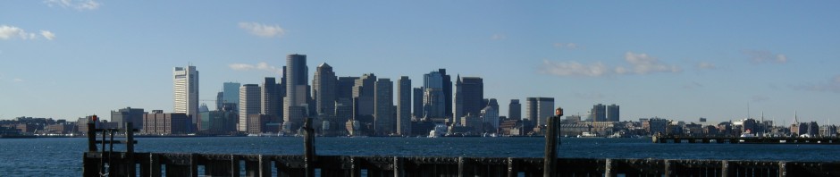
Langlee is the outermost, sitting between the Hingham Yacht Club on Crow point, and the fields of Planter’s Hill on World’s End. Button Island is the closest to shore and most visible. The terrain of the islands is comprised of rock, and the long, low cliffs that line its shores bear the high water mark that is visible at low tide. Below is view of Hingham Harbor and the Boston Skyline, looking Northwest from the cliffs on the North side of Langlee Island:

Long view hingham

According to The History of the Town of Hingham, which was published by the town in 1893, a gentleman by the name of John Langlee purchased the island in 1686- a purchase from which it derived its current name. Langlee was likely born in England and came “in early life” to Hingham according to the documents. It is likely that nearby Sarah island was such named due to the fact that was a popular name in the family: Langlee’s wife, daughter and granddaughter were all named Sarah.

The latter Sarah became Sarah Derby once she married Richard Derby, a member of the well known Derby family of Salem, for which Derby Wharf is named. She is also known as the founder of Derby Academy in Hingham. John Langlee lived in what is now downtown Hingham, and today has a street bearing his name in Hingham near crow point.

A conveniently placed sign on the island, letting you know you have arrived:

Hingham Harbor

Pictured below is a small cove on the Eastern side of Langlee which allows access for small boats:

hingham

Looking South from Langlee Island, towards the other Hingham Harbor Islands, Sarah Island and Ragged Island:

Hingham Bay

At low tides, sometimes these islands are nearly connected to land, as can be seen in the link. Another interesting perspective can be seen here, featuring the Hingham Harbor Islands, Grape Island and World’s End as seen from an airplane before landing at Logan Airport. Below is a view of Langlee island and some of the moorings on Hingham Harbor as seen from the hills of World’s End:

Langlee Worlds End

Hingham Harbor on a foggy, fall day, with the air so calm there is hardly a ripple on the water. Button Island, the smallest of the bunch can be seen in the foreground:

Button Island

The Hingham Yacht club as seen from the cliffs of Langley Island, with the City of Boston in the background:

boston harbor

Posted in Boston Harbor Day Boat Trips, Boston Harbor History, Boston Harbor Navigation, good views, Uncategorized | Tagged , , , , | Comments Off on Langlee Island and the Inner Hingham Harbor

Summer Views of Peddocks Island

Last week, I returned to Peddocks Island for the first time in over a year. It was a bright blue sky day. The island was very ho, and the grass and brush of the island’s long, low-lying center was very dry having been bleached by the sun this entire dry summer.  Elsewhere, I was pleasantly surprised by the work that had been done to fully update the old chapel near the island’s main dock in Hull Gut. Check out the pictures below, and while you are at it, take a look at some previous photos of Peddocks including those of Fort Andrews and the island in the early Spring, and the Prince Head on the Southeastern side of the island.

Hingham bay and the tug boat anchorages on the Island’s East side:

east harbor

A stark view of dry brush surrounds the main trail as the sun beats down:

boston harbor

A rusty old automobile chassis is one of the many relics one can find when walking through the high grasses on the long, flat tombolos (geological name for a sandbar) on the island:

peddocks island

Looking West toward the city from the shores of Perry Cove:

peddocks

Summer sunset over Peddocks:

Boston Harbor Sunset

Looking towards the West Head from one of the higher points on the East Head. From this view point, one can see how long the shoreline of Peddocks Island is- in fact, it has the longest shoreline of any of the Boston Harbor Islands.

Boston Harbor

Looking back on the trail toward the East Head, where Fort Andrews is located:

Boston harbor trails

A previous photo taken from a similar vantage point at the opposite time of the year (early March). Somewhat of an interesting contrast:

winter paddocks contrast

Following the old trail further as it goes into the woods in the island’s middle head. A small village of fisherman’s homes- some occupied but many abandoned- lies off this main road.

Peddocks Island

The leaves of many plants seemed to have started to turn yellow and orange as early as August, perhaps due to our hot, dry summer:

Peddocks Hingham Bay

The old brick buildings near the parade ground on a late summer day:

Peddocks Summer

An old engine block, revealed by the low tide. I tried to make out a brand or some markings, but the sea had her too long. Nothing was recognizable.

Peddocks Island

Posted in Boston Harbor Day Boat Trips, Boston Harbor History, Boston Harbor Navigation, Uncategorized, Visiting Boston Harbor | Tagged , , , , | Comments Off on Summer Views of Peddocks Island

A Squantum View: The Boston Harbor in Contrasts

Below is a panoramic view of Squantum seen earlier on this bright, blue sky Saturday, where the east wind whipped up whitecaps across the blue sea which mirrored those clear skies:                                                         

                                                                        (Click to enlarge)

boston harbor

This view of this incredible place on a gorgeous late summer day shows off what modern Boston Harbor is all about….a scene of great contrasts, as some of the places that have historically been the harbor’s dirtiest and nastiest now look so beautiful!  I feel fortunate to be a beneficiary of the progress this city has made at cleaning up the harbor.

Consider the following: The large pipe of the east shaft of Boston’s 1880s-vintage sewer system is in the foreground- a system that would dump raw sewage daily into the outgoing tide as late as the early 1980’s. But today, this long-shut system sits as a relic in front of  glistening, clean water surrounding our cityscape in the background. To the left is Thompson Island, and further behind that lies the high drumlins of Spectacle Island. The latter, once the home of a toxic dump and rendering factory, is now home to the tree-lined trails of a National Park. Barely visible behind Spectacle are the blades of Deer Island’s wind turbines, generating renewable energy for a water treatment plant that keeps the harbor’s waters clean.

Posted in Boston Harbor History, Boston Harbor Navigation, Boston Harbor Picture of the Week, good views, historical place of the week | Tagged , , , | Comments Off on A Squantum View: The Boston Harbor in Contrasts

Photo of the week: Liberty Clipper in Boston Harbor

Boston Harbor


The Liberty Clipper in Boston Harbor on a calm day. This view is looking East from the inner harbor.

Posted in Boston Harbor History, Boston Harbor Navigation | Tagged , , | Comments Off on Photo of the week: Liberty Clipper in Boston Harbor

Hangman Island: A low lying rock outcrop in Quincy Bay

City View

Located in the center of Quincy Bay, Hangman Island is comprised of several small, low lying rock outcrops connected by sandbars. Lacking prominence, the island is often only noticed as one passes through the Western Way channel and looks south. Even from points along the Quincy shoreline, one might only notice Hangman Island when gazing across its landscape at low tide, when the bay is littered with flats and pools.

A brief history: I have heard it said that Hangman’s Island was named for its original eighteenth century inhabitant, a Norfolk county hangman who after overseeing many executions became a miserable old hermit and occupied the island in solitary isolation. However, the King’s Handbook of Boston Harbor suggests that this story is likely untrue, as it reports that the location was labeled “Hayman’s Island” on a chart published in London in 1775, giving rise to the idea that the name the island was after some gentleman named Hayman, and that the previous story was just contrived over time.

It is said that the City of Quincy never took possession of the island, and I have read that when a businessman named Putnam once tried to obtain a deed to the  island in the early nineteenth century, neither the mayor of Quincy nor John Adams knew who owned the pile of rocks. The island did have inhabitants over the years, the names of many are listed by Edward Rowe Snow in “The Islands of Boston Harbor”. There are no known military structures on the island, but there are some remains of a structure which suggests the island certainly once did have some development. Perhaps it was part of a lobster shack  said to have been occupied in the late 1800s by a lobsterman named Bill Greenfield* who was said to have rescued many a stricken sailor in Quincy bay over the years. The photo below shows some type of old frame board ridded with nails, that may have once been part of a bigger structure. It also illustrates just how close the island is to downtown Boston given the perspective of the Prudential tower in the backdrop:

quincy bay

*The Boston Globe “Can’t Count Lives Saved” August 22, 1897.

A view of Hangman Island at low tide, with Rainsford Island and and Long Island both visible in the background. At high tide, the island is much less visible. I have read that the shallow flats around Hangman formed from dumping fill that was produced from the Western Way channel excavation. When traveling in that channel, as the Hingham Ferry does daily, Hangman Island is visible to the south of the Channel about half way between Nut Island and the Long Island Bridge.

rainsford

A full, low tide view of Hangman Island, looking West toward Thompson Island and the City of Boston:

Quincy Bay

Posted in Boston Harbor History, Boston Harbor Navigation, Uncategorized | Tagged , , , | Comments Off on Hangman Island: A low lying rock outcrop in Quincy Bay

The Gurnet Point Light

Plymouth

Gurnet Point is an isolated outcrop of land lying at the end of the Duxbury Peninsula and located within the Town of Plymouth, Massachusetts. Accessible only by driving over sand, the area is far removed from other parts of the South Shore and is more easily viewed by boat than from automobile. At the end of this sandy point lies some drumlins or cliffs similar to those found to the North in Scituate, and on top of the highest point sits the Gurnet Light, which served over the centuries as a beacon to guide ships safely into the ports of Plymouth and Duxbury.

What may not be as well known is that Gurnet Point was once outfitted with not one, but two lighthouses, or a pair of “range lights” as they were called. Like many locations in Massachusetts Bay situated near a major shipping channel-such as Spectacle Island, Lovell’s Island and Baker’s Island– two range lights were constructed to guide ships into port by following the trajectory in which the lights could be seen converging. Likely driven by the advent of more modern technology, the range lights which stood for over one hundred years were replaced in December 1923 by the single lighthouse structure that stands today. Pictured below is one of the Fresnel Lenses (3rd order) which sat atop one of the Gurnet range lights, until it was finally taken down in 1923 and placed in the Hull Lifesaving Museum:

Gurnet Light

As one can image, the documented history of the Gurnet Point goes back quite a bit further than the construction of its new lighthouse in 1923. The peninsula was likely named for a Gurnet Point in England by early British colonists, and this point was most certainly viewed by the original Pilgrims as they entered Plymouth Harbor in 1620. However, an earlier known reference to the area was recorded: In a 1613 account of Champlain, he described the are as “almost an island, covered with trees, principally pines”.*  The dense pines indigenous to the area likely have lent name to the High Pines outcrop lying less that two miles to the North and the High Pines ledge located just offshore.

* “Life at the Gurnet”, Boston Daily Globe, December 27th, 1896

Gurnet point had a well known lifesaving station, as did Manomet Point located several miles to the South- both were known to exist since the 1700’s. During revolutionary times, the area around Gurnet was home to a fortified earthwork which was occupied by up to sixty soldiers. In the war of 1812, the fort was refitted and reportedly sank a British ship which came within firing range. The fort was rebuilt during the Civil War, and renamed Fort Andrew (not to be confused with Fort Andrews at Peddocks Island). The Fort was named for John Albion Andrew, who was governor of Massachusetts during the civil war and a fervent abolitionist. While the outline of the original earthworks is very visible from any aerial view of the Gurnet Point, the exposed brick structures below the lighthouse in the first photo at the top of the page may have belonged to the original fort as well.

Gurnet Point as viewed from the approach into Plymouth Harbor and Duxbury Bay:

plymouth

Below is a view of Gurnet Point and Clark’s Island looking South, with the dunes of Cape Cod’s bay side distantly visible in the background. The photo was taken from the top of the Standish Memorial in Duxbury:

plymouth

Gurnet Point as seen from Plymouth Plantation across Plymouth Bay:

DSC_1719

A chart of Gurnet Point, south of the Duxbury Peninsula, but situated at the north entrance of Plymouth Bay:

gurnet light

NOAA Nautucal Chart. See NOAA.gov for disclaimer.

Posted in Boston Harbor History, Boston Harbor Navigation, Boston Harbor Picture of the Week, Uncategorized | Tagged , , , , , , | Comments Off on The Gurnet Point Light

Whaleship Charles W. Morgan in Boston Harbor

The whaleship Charles W. Morgan left Boston yesterday morning to head back south. She had been in Boston for the past couple of days as part of her 38th Voyage. The ship is the oldest remaining wooden whaleship in the world and is the second oldest commercial ship in the country still afloat (the USS Constitution is older). You can read more about her and her home in Mystic Seaport, Connecticut here.

Castle Island

Charles W. Morgan In front of the city, heading out to sea….low resolution since she caught me by surprise and I didn’t have my preferred camera with me:

Whaleship boston harbor

Far off the Cohasset Coast on her way South down to the Cape Cod Canal:

Cohasset


Posted in Boston Harbor History, Boston Harbor Navigation | Tagged , , , , | Comments Off on Whaleship Charles W. Morgan in Boston Harbor

Picture of the Week: Liberty Schooner

One of the beautiful Liberty Schooners in Boston Harbor yesterday afternoon, July 18th.

boston harbor

Posted in Boston Harbor Navigation, Boston Harbor Picture of the Week | Tagged , , | Comments Off on Picture of the Week: Liberty Schooner

A German Ship in Boston Harbor during WWII: The story of the Pauline Freiderich

So much of Boston Harbor’s modern history and the landscape of its islands and shores was shaped by war. The story of the Pauline Freiderich is one of the more obscure WWII-era events that occurred here.

It was September 4th, 1939 when the Captain Ernest Heintzmann of the Pauline Freiderich received an important telegram off the coast of Nova Scotia. The vessel was several days into a return voyage after taking on a cargo of oil from Port Arthur, TX, en route to her home port of Hamburg Germany. After what he heard, Captain Heintzmann knew that there would be little chance of crossing the Atlantic and arriving home in Hamburg unharmed. Hoping for the best, he turned the ship around and set a course for Boston Harbor.

An artistic rendition of the Pauline Freiderich:

boston harbor


Little did crew or captain know of the events of September 1st 1939 as they headed out of the bayous of Port Arthur, around the Florida Panhandle and onto a Northeastern course.  What did happen on that fateful day- the sudden and devastating invasion of Poland by Nazi Germany- the “Blitzkrieg” -set into motion a series of events leading to the beginning of WWII, starting most promptly with the declaration of war on Germany by Great Britain.

The Pauline Freiderich awkwardly entered the port of Boston, and was permitted to dock given the neutrality of the United States at the time. While docked at Battery Wharf in the City’s North End, she was likely both a spectacle and an annoyance for British ships passing through the port. According to most reports in the news, the crew was treated well- they were allowed to attend events on the mainland and entertain visitors. While not to their knowledge at the time, the crew and their visitors were begin heavily monitored by the FBI. One visitor to this ship that caught their attention was William Colepaugh, an American traitor who would later accompany SS spy Eric Gimpel on an espionage mission through the US after being dropped off by a Nazi U-boat at Point Hancock, ME.

Maritime law at the time granted a visiting ship 60 days in port. Toward the end of that time frame, the crew sabotaged the ship, destroying the engine room so as  not to have to cross the Atlantic and return to Germany. Following this incident, the cargo of oil was confiscated, and the crew members were charged with sabotage. They were permitted to stay on the ship, but that all changed after December 7th 1941 when the US entered the war against Germany and Japan following the bombing of Pearl Harbor. The crew of the ship was immediately arrested and interred at a military camp for the duration of the war. As the US entered the war, Nazi ships went from being tolerated to greatly feared: A giant field of mines lined the entrance to the harbor to prevent attack or espionage. Still, German submarines lurked off the coast of Boston and were said to even enter the harbor, with a documented encounter happening on a June evening in 1942.

Given her age and obsolescence- her capacity of 1.75 million gallons was only about half that of modern tankers of the time- one may have thought the Pauline Freiderich would be scrapped during or shortly after the war. However, with capacity in high demand and shipbuilding facility working at full steam, the tanker was repaired and used in the United Nations Merchant Marine.  This was not the only German Vessel seized by the united states- famous examples include the Horst Wessel, Now the Coast Guard Eagle, and several U-boats, one of which was scuttled offshore, and one which is on display in the Chicago Museum of Science and Industry.

Sources:

War Tension on the Waterfront as Nazi Tanker Halts Here. The Boston Daily Globe, September 4th, 1939.
Tanker Wrecked Beyond Repair by Nazi Crew Here. The Boston Daily Globe, April 1, 1941.


Posted in Boston Harbor History, Uncategorized | Tagged , , , | Comments Off on A German Ship in Boston Harbor during WWII: The story of the Pauline Freiderich

The Shipbuilding and Manufacturing History of the North River

ship building

For over 150 years, some of the largest shipyards in America were located along the banks of the North River, in what are now the towns of Norwell, Pembroke and Hanover. The locations of the shipyards were far upstream, several miles from the river’s mouth. The location of the Brick Kilns Shipyard, noted on this 1794 map was located near what today is its namesake street off route 139 in Pembroke. Other shipyards were located across the river near the present day location of the Brigantine Circle development in the town of Norwell. Further downstream was the Brooks-Tilden Shipyard in North Marshfield, which is a now conservation land owned by the town.

A modern view of the North River near its mouth at the Scituate-Marshfield line:

north river

Perhaps the most famous ship to be built in the North River shipyards was the Brig “Beaver” which was owned by the British East India Company. Docked in Boston Harbor with a full load of Tea on the night of December 16th, 1773, American Revolutionaries snack aboard and threw the tea into the harbor in an event which would henceforth become known as the Boston Tea Party.

Equally interesting but likely less well known is another North River-built ship, the Columbia. The first American ship to circumnavigate the globe, she was was used in the booming trade with China. Columbia was under the command of Captain Robert Gray on trips to Canton, China. Finding himself outbid by European merchants trading gold and  silver, Gray had the idea that he would obtain furs to trade from the American Pacific Northwest en route to China. Hearing rumors of a great river in the Northern Pacific, he set out to find it. According to records* it was May 12th, 1792 when Captain Gray first spotted a great open bay and a wide river along the Pacific coast. He named the river the Columbia after his ship. This name still holds today, as does the name Gray’s Bay. Visible on any modern map, these vast bodies of water separate the states of Oregon and Washington. Today, the city of Portland, Oregon is located at the intersection of the Willamette and Columbia Rivers.

A model of the Ship Columbia, located in a restaurant in Marshfield, Ma:

columbia ship

An artist’s portrayal of the Columbia:

Columbia in a Squall

By George Davidson, artist painter who served on board the Columbia Rediviva. [Public domain], via Wikimedia Commons

The banks of the North River between Marshfield and Norwell, not far from where the shipyards were located. This part of the North River is easily accessible from several Marshfield conservation land parks off of Union Street, including the Norris Conservation land, and Stetson Meadows, pictured below:

marshfield ma

A view of the North River from the Norris Reservation, just across the river from the land which the Brooks-Tilden shipyards once occupied:

Norris Reservation

Further upstream in the towns of Pembroke and Hanover, the North River is formed by several tributaries including the Indian Head River, the Iron Mine Brook and the Herring Run. These converge at a point called Luddam’s Ford, which was named for a guide named John Luddam who was said to carry the Governor John Winthrop across the stream on his back in 1632 while on the way to Weymouth. This area was once home to several heavy industries, including an anchor fabricating plant where the anchor of the USS Constitution was made in 1797. More recently, the area was occupied by a rubber company owned by Eugene Clapp, which was lost in a fire in February 1924. A photograph of that factory and its surroundings from that time period is on display at the park. Below are several photos of the Luddam’s Ford Area, including the falls and factory remains:

Waterfall

Pembroke

Luddam's Ford

Iron Factory

Indian Head River


*The Maritime History of Massachusetts, 1783-1869. Samuel Eliot Morison** History of the Town of Hanover, Jedediah Dwelley and John F. Simmons, 1910. 
Related Posts Plugin for WordPress, Blogger...
Posted in Boston Harbor History, Boston Harbor Navigation, Uncategorized | Tagged , , , , , , | Comments Off on The Shipbuilding and Manufacturing History of the North River