Fishing boats were locked in place by ice on this cold New Year’s day in 2014:

Fishing boats were locked in place by ice on this cold New Year’s day in 2014:
A unique view of the Boston Harbor and Massachusetts Bay: The Long Island Bridge in the foreground, with Gloucester’s wind turbines in the background. This edited and highly zoomed-in photo was taken from the top of the Granite Links Golf Course in West Quincy:

Several of the harbors around the south shore are celebrating holiday spirit, including Cohasset, where they have a lobster trap tree, and Scituate, where a nice wreath was recently hung up on the Lighthouse:


Heading across the Atlantic Ocean is something that I have always found fascinating. Between the vast expanse of raging North Atlantic and the contours of the sub-arctic coastlines, there is a constant flow of good scenery below throughout the roughly seven hour westbound journey back to Boston from London. Often the strength of the polar jet streams force westbound jets to high latitudes where they can avoid the strongest headwinds and make an easier passage. Such was the case in the pics seen below, shown in reverse chronology on the trip home from London:
The Boston Harbor and City Skyline as seen from above and about ten miles to the East. This was taken as the plane (Virgin A330-300) headed south before banking to the northeast to make its final decent into Logan:

Approaching the frozen coast of Northern Labrador, about an hour and a half out of Boston:

The location as seen on the in-flight map:

Passing Greenland’s southern tip:

A better view of South Greenland from a different flight several years ago (American 767-300). This is probably the best shot of Greenland that I have:

Scotland: Passing Berneray Island and Pabbay in the Outer Hebrides, a remote and spectacular group of glacially-carved islands on the northwestern side of Scotland. Normally, a transatlantic light will not head on a trajectory this northerly, but on this day the winds were particularly strong:

A striking landscape of Northern Scotland, where deep valleys cut from the ocean into snow-capped mountainous inlands. Loch Shiel is visible below:

The approximate route over the Hebrides as seen on the map:

Pulling up out of Heathrow heading East, and taking a big turn up to the North. London’s green western suburbs can be seen below on a sunny, late autumn day:

For more interesting photos from the air, including some from the Boston area and Massachusetts Bay, check this link out.

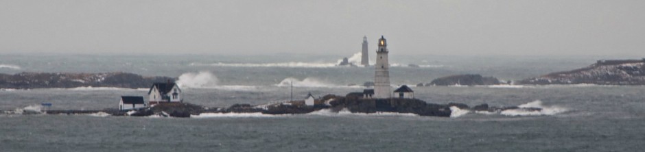
Minot light getting pounded by huge surf in the storm of December 14th, 2013. Offshore buoys recorded wave heights of over twenty feet this morning.
The Boston skyline as seen from Thompson Island:

Saturday afternoon was exceptionally calm: The lack of wind made Dorchester Bay look as flat as a pond. The low tide exposed the sandbar to Thompson island, where I was able to walk and take in the view of the city skyline and its reflection.
The outer Boston Harbor has once again become a fertile fishing ground. Boats converge on the ledges and flats to pursue both lobsters and fin fish, coming from the harbors of South Boston, Hingham, Hull and Winthrop, among others. Below are some of the photos I have taken over the past year of some of these boats in action in various spots around Boston Harbor and Massachusetts Bay. The photos are faded to obscure the little details, so one can focus on the scene and the big picture:
Lobstering near Martin’s Ledge, Northeast of Boston Light:

A fishing boat passing Sheep Island in Hingham Bay, on its way back into harbor:

A lobster boat heading back into the inner harbor at sunrise:

A charter boat heading along Nix’s Mate channel:

A lobster boat on its mooring at Hewitt’s Cove, Hingham:

A lobster boat passing Nut Island on a summer morning:

Pulling up traps in the West Gut, South of Peddocks Island, with many Boston Harbor Islands visible in the distant background:

A heavy trawler, passing the inner harbor en route to the fish pier:

A lobster boat near the rip off Deer Island Light:

Heading out past Long Island on a calm, smooth summer morning:

A lobster boat working Nantasket Roads, just inside Boston Light:

Fishermen ready their equipment while passing the dunes of the north side of Peddocks:

A fully loaded lobster boat heading back home on the open ocean, just east of Outer Brewster Island.

Scituate: A fishing boat sitting at its mooring in an otherwise empty Scituate harbor on a mid-winter day:

Gloucester: A dragger passing ten pound island on its way back into Gloucester Harbor:

Cohasset Harbor: Lobster boats drift on their moorings on a bleak winter day:


November’s full moon last week: As seen at dusk, from high at the top of Whitney Woods in Cohasset, overlooking Massachusetts Bay.
The most noticeable characteristic of Grape Island may be its close proximity to the mainland of Hingham and Weymouth. Located just outside of the Weymouth Back River’s Mouth, the island may be literally a stone’s throw away from Weymouth Neck’s Webb Memorial Park at low tide. Also immediately clear is the densely wooded interior of the island, a sharp contrast to some of the many rocky, barren islands of the harbor. Few of the Boston Harbor islands are as densely wooded, with Peddocks Island being perhaps the only exception.

Pictured above an old Willow tree, likely planted during the time of the island’s agricultural use, sits at the eastern end of the island.
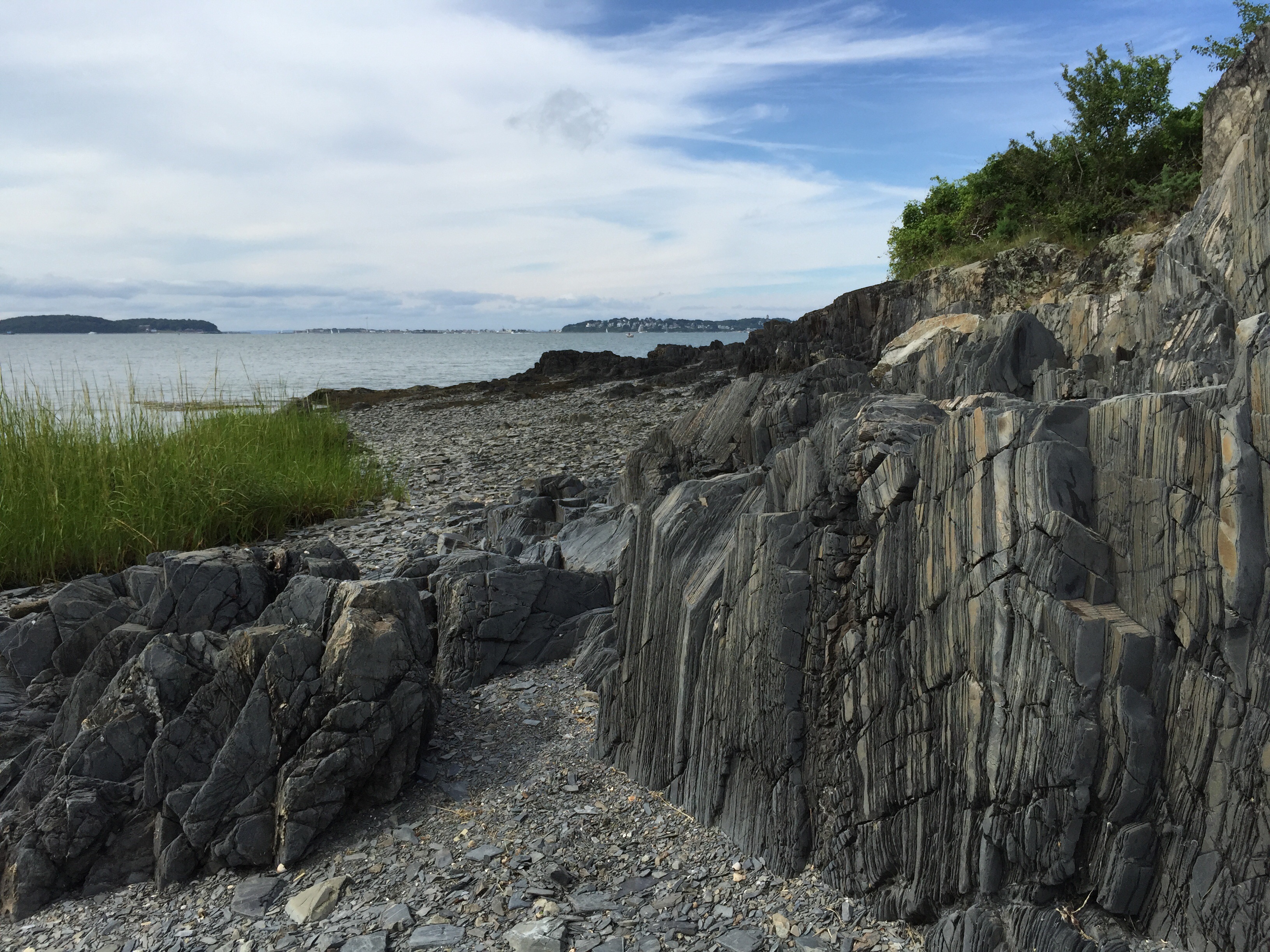
In addition to its namesake crop of grapes growing on a vine near the dock, Grape Island possesses a local herd of white tailed deer, several massive oak trees, and allegedly two freshwater springs, which remain off the main path and hidden. Grape Island’s wooded highlands are not its only differentiating geological feature: Its shores are as well. The island’s shores are so flat and gradual, that the island’s area nearly doubles in size at low tide. The low tide reveals banks covered in sea shells as well as dark, slate and granite rocks which compose the terrain of the area, including the smaller nearby rocky (and appropriately named) outcrop; Slate Island. Below, a view to the north with nearby Slate Island and the town of Hull both visible in the background:

The foundation of a house once inhabited: Relative to the other islands of Boston harbor, Grape Island has few structural remains. However, we do know the legends of some of the island’s previous inhabitants. These are said to include the reclusive Amos Pendleton, also known as the Pirate Captain Smith, who inhabited the island after the Civil War, after spending years as a sailor on the open seas. The location was later occupied by a captain named Billy McLeod until his death in 1935, after which time the land was taken over by the Federal Government.

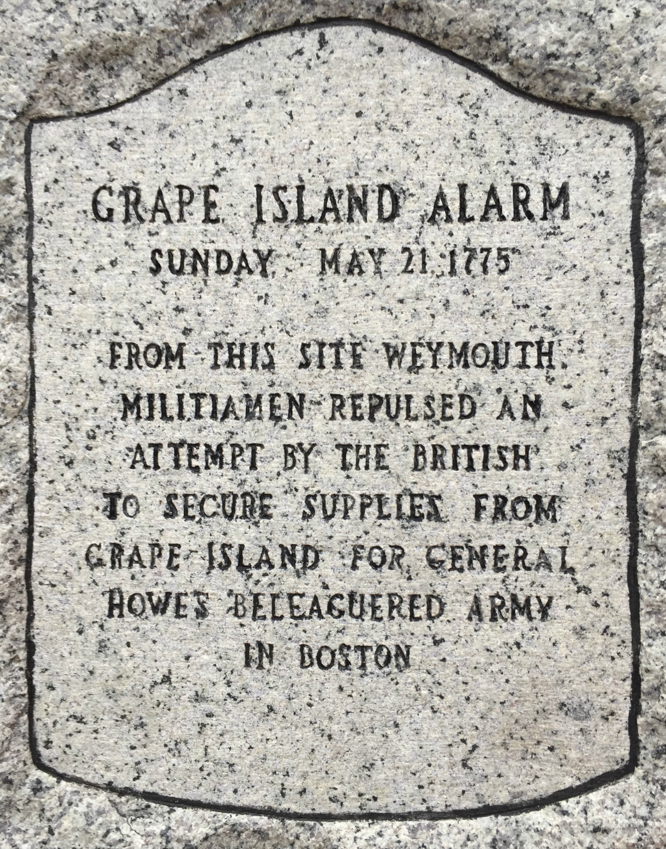
Perhaps the most interesting story of Grape Island’s inhabitants is that of one of its earliest owners, Elisha Leavitt, a colonial loyalist and resident of nearby Hingham. In allowing the British Fleet occupying Boston in 1775 to use his hay to feed their horses, Leavitt incited a battle at Grape Island in which local militia drove back the oncoming British forces as they landed to gather hay for their horses on a May evening of that year. Initially documented by Abigail Adams, the details of the battle are memorialized with a stone across the channel from Grape Island at modern day Webb Memorial Park in Weymouth. The location of this stone is at the place which is said to have been used as a staging point in the battle.
While the patriots prevailed against the British and Leavitt on May 21st, 1775, the later story goes that an angry crowd of local residents subsequently headed to Leavitt’s home in Hingham to find and punish him for aiding the British. It is said that Leavitt was able to diffuse the tense situation by offering the enraged crowd a keg of Whiskey. In the end, they spared his life….but still burned down his barn. A street bearing Mr. Leavitt’s name still exists today in Hingham.
Pictured below, a trail up the hill to a large tree which looks like an oak. The island possesses several types of trees, including willow, oak, birch, aspen, and of course ample sumac, the major indigenous plant of the Boston Harbor Islands. Grape Island is a lesson of the power of natural succession, as wild growth has rapidly overtaken this once cultivated land in the mere seventy years in which it has been abandoned.

Grape Island is known for its gradually sloping shore which cause it to double in area from high tide to low. At low tide, the dark, slate rock formations characteristic of the area become more exposed. Below is view looking towards the much smaller Slate Island, which lies to the east of Grape Island and was once used as a quarry in colonial times. During astronomical low tides, Slate Island is actually connected to the mainland- Crow Point in Hingham- by exposed sand bars on its South side.

Below is a view of the Western side of Slate Island, with its great rock outcrops that it was evidently named for. Further in the islands interior is said to be remains of a rock quarry, but access is not recommended due to uneven terrain and an abundance of poison ivy.
The view looking west to the city of Boston from the rocky northern shore of Grape Island. In the distance, one can see the West Gut, the South side of Peddocks Island, and the infamous Pig Rock. The Long Island Bridge is also visible far in the distance:

A view to the north of Grape Island, toward Sheep Island, visible in the foreground, with Peddocks Island visible in the background:

The south shore of Grape Island is lined with shells, as is typical of the south facing shores of the Boston Harbor islands:

Grape Island’s Dock, with the Fore River Lift Bridge connecting Weymouth to Quincy in the background, highlighting the close proximity of the island to the mainland. Grape Island is one of the easiest islands to access due to its location and logistics. The ferry service, which runs in the summer from both Boston and Hingham provides easy access. As for access by private boat, anchoring nearby, especially on off the smooth and sand southwestern shore is ideal. However, the waters here are very shallow, so boaters beware, and approach slowly!

The location of Grape Island, just outside the Weymouth Back River, and just across the channel from Web State Park- a channel which gets very narrow at low tide:


Fall sunset over Hingham Harbor.


