Subscribe
-
Recent Posts
Categories
- boston development
- Boston Harbor Birds
- Boston Harbor Cruises
- Boston Harbor Day Boat Trips
- Boston Harbor History
- Boston Harbor in the Winter
- Boston Harbor Navigation
- Boston Harbor Picture of the Week
- Boston Harbor Tides
- Boston Harbor Walks
- Boston Harborfront Development
- boston local issues
- Boston Whaler
- Commuter Boat
- Fishing
- good views
- historical place of the week
- Off course
- Tour Boats
- Uncategorized
- Visiting Boston Harbor
- Weather
Boating & Fishing Links
Archives
- November 2015
- September 2015
- August 2015
- February 2015
- January 2015
- October 2014
- September 2014
- August 2014
- July 2014
- June 2014
- May 2014
- April 2014
- March 2014
- February 2014
- January 2014
- December 2013
- November 2013
- October 2013
- September 2013
- August 2013
- July 2013
- June 2013
- May 2013
- April 2013
- March 2013
- February 2013
- January 2013
- December 2012
- November 2012
- October 2012
- September 2012
- August 2012
- July 2012
- June 2012
- May 2012
- April 2012
- March 2012
Tag Archives: boston skyline
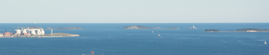
Boston harbor and skyline as seen from the top of Blue Hill
The city of Boston as seen from the summit of Great Blue Hill. Click to Enlarge: Just over ten miles South of downtown Boston lies Blue Hills, a park comprising 7,000 acres of rolling hills. At 635 feet, the tallest … Continue reading
Posted in good views, Visiting Boston Harbor
Tagged blue hill, boston harbor, boston skyline, boston view, chelsea river, deer island, Hingham, long island
Comments Off on Boston harbor and skyline as seen from the top of Blue Hill
Boston Skyline and International Place from the Harbor
The towers of International Place and Rowes Wharf as seen from the Boston Harbor. This photo of Boston’s wonderful skyline was taken early on a calm winter morning from the commuter ferry. The sun was bright, and the wind was … Continue reading
Posted in boston development, Boston Harbor in the Winter, Boston Harborfront Development, Uncategorized, Visiting Boston Harbor
Tagged boston skyline, boston waterfront, buildings, international place, rowes wharf
Comments Off on Boston Skyline and International Place from the Harbor
The Central Artery: How Boston’s waterfront once looked
The Central Artery, the giant metallic green overpass that once wound its way through Boston’s busiest downtown streets, is now long gone. However, it defined the waterfront cityscape for a great many years, which is why I wanted to share … Continue reading
Posted in Boston Harbor History, Boston Harborfront Development, Uncategorized, Visiting Boston Harbor
Tagged boston skyline, boston skyline at night, boston waterfront, central artery
Comments Off on The Central Artery: How Boston’s waterfront once looked


