Sunset out at Graves Light

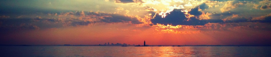
Here are a few photos of Sunset out at Graves Light, Friday evening, October 26th. Recall Graves light is the abandoned lighthouse on Graves Ledge, the outermost outcrop of rock in the outer Boston Harbor:

The Sun sets directly behind the light house in this picture, note the sillouette of the city skyline in the background:

Approaching the lighthouse and ledge:

Looking Southwest towards the city:

The city skyline behind the Northeast ledge of Graves:

This was one of the better sunsets I have seen out at Graves Light, since it was such a clear night and there were no clouds over land West of the city (which is uncommon).

Below is the approximate location by GPS where these photos were taken. Boaters who approach Graves Light should be very cautious given the underwater obstructions near by, particularly the Graves ledge which extends several hundred yards Northeast of the visible rocks near the lighthouse. This is somewhat visible in the char below, and is well marked at the end with a green can. The roaring bulls are another major boating danger in the area. Here is a link with a more detailed description.

Heading back home in a Southern direction:

Heading back home in Hingham Harbor as the sun goes down:

Posted in Boston Harbor Cruises, Boston Harbor History, Boston Harbor Navigation, Uncategorized, Visiting Boston Harbor | Tagged , , | 1 Comment

New Gloucester wind turbine visible from afar

You can see it! Last Saturday, I noticed the structure off the Northeast while I was out in the bay East of Boston Harbor. The new wind turbine in Gloucester is very clearly visible to boaters from outside Boston Harbor, and as it turns out, is even visible from as far away as the South Shore: Specifically, Turkey Hill in Hingham and the cliffs over Jerusalem Road in Cohasset. As such, this adds a great location point for boaters to help them determine there position and direction while far out on the wide open sea. The Gloucester turbine will be a good visible marker along with the Pilgrim Monument in Provincetown, The Salem Power Station, the Lawson Tower and Driftway Wind Turbine in Scituate, and Thacher Island in Rockport.

Note these pictures aren’t the clearest, but this is because they are taken of something 22 miles away….A clear, pretty picture isn’t what I’m trying to do here…this is all about the perspective and distance.

Here is a long distance shot of Gloucester Harbor from Turkey Hill in Hingham, with the wind turbine visible. The elevation gives some advantage:

gloucester


Update: A newer photo, on a clearer day in late December ’12. The furthest right turbine is even more visible now that its fan seems to have been attached:

Gloucester

For some more panoramic shots from Turkey Hill, click here.

Here is a photo (highly zoomed in with my Nikon) of the wind turbine, as taken from the shore in Cohasset. Note it is in the distance right in front of the blue tanker, which is anchored at the offshore gas terminals:

Looking out across Massachusetts bay from the South Shore to the North gives one some perspective on the size of this vast area. I have been able to see the lighthouse at Eastern Point in Gloucester from the high points of Jerusalem Road. Likewise, I have also seen Minot Light from the Dogbar breakwater in Gloucester. Here is a panoramic shot of the North Shore taken from Turkey Hill on the Hingham/Cohasset line (you may have to click to zoom in on this one):

Gloucester from Hingham


Posted in Boston Harbor Day Boat Trips, Boston Harbor Navigation | Tagged , , , , | 1 Comment

November on Boston Harbor

There are still opportunities for boating even in November on Boston Harbor. It is cold, often windy, and the harbors are largely empty with the exception of commercial fleets. shrink wrapped boats line the shores.

It was a cold blustery Saturday out on the water yesterday, serving as a reminder that the boating season is getting close to an end. There seems to always be that one warm, sunny November day that is worth staying in the water for, but yesterday was not that day! It was, however, a sunny afternoon, in which the November sun setting in the distance creates a purple-ish tone in the sky which was quite beautiful. I headed out toward the B buoy yesterday for what was likely my final voyage of the 2012 season, mostly to check on the boat to make sure she fully survived the hurricane. I didn’t stay out long, as the wind was howling and the air was cold. Above is a photo of a container ship as it heads out to sea from Nantasket Roads.

The Salacia is still running. Here it is passing Boston Light:


Pulling into Hingham Harbor for my last trip of the season:


A shot taken from Scituate Harbor. Its cold and not a lot is going on:

Photos taken out Beyond the Harbor entrance on a dark November day in years past. As the sun went down early in the afternoon, a reddish tone appeared behind the city which was quite nice:

Cruise ships line up under a dark and blustery November Sky:

Posted in Boston Harbor in the Winter, Uncategorized, Visiting Boston Harbor, Weather | Tagged , , , | Comments Off on November on Boston Harbor

Hurricane Sandy

Here are two Hurricane Sandy photos taken during the peak of the storm (around 5PM) from Jerusalem Road in Cohasset, looking Northeast toward open ocean. Below is a picture of a giant wave coming in, probably the biggest I have ever seen on the East Coast. This giant wall of water is probably close to 20 feet high. Keep in mind I am standing on some cliffs that are about 40 feet above the water:

Looking North. Long, sweeping waves averaging 10-15 ft as the storm hits its peak. Its hard to imagine that this is the same angle and position where I took this photo just a few weeks ago!

Earlier photos, taken around noon:


Hurricane Sandy has arrived with fury! I’ll constantly update this post throughout the storm, but at the present time (4:30PM) it looks like we are in the thick of it. I went and checked on my boat at the Hingham Shipyard Marina at hight tide (11:41AM in Hingham) and was happy to see that despite the lunar high tide and storm surge, there was still plenty of height between the dock and the top of the pilings holding it in place. My hope is that the surge subsides by the next high tide at midnight.  Above is a picture from Black Rock Beach in Cohasset just after 1PM. However, the storm has since strengthened. The picture above does not do it much justice, but these waves are 8-10 feet as they break near shore.

In terms of the current weather, NOAA buoy 44029 in Mass Bay is now reading 23 foot dominant wave height at the time I write this! I am reading about sustained wind speeds at 40MPH with gusts up to 60MPH, which I would believe since the wind has ripped a tree out of the ground-roots and all- in my front yard!

My dock in Hingham at exactly high tide today (11:41AM):

The Eastern wind fetch at Hingham Shipyard. It actually doesn’t look that bad, as of today around noon:

Black rock beach. Such violent surf rips up all the muck (note all the stones flying):


Assessing the damage: I noticed that it was not too bad in our part of the coast, although the Rowes Wharf ferry terminal pilings were pushed to an angle (see below) and there was a lot of debris washed ashore, such as the old lobster trap second below:

Posted in Boston Harbor in the Winter, boston local issues, Weather | Tagged , , , , , | Comments Off on Hurricane Sandy

Boston Harbor Picture of the Week: Lighthouses

Despite being 2.7 miles apart, these two Lighthouses, Boston Light and Graves Light look very close together when viewed from Fort Revere in North Hull. Here is a shot of Boston Light in the foreground, with Graves in the back, while a fishing boat cruises past in Nantasket Roads.


The area separating these two lighthouses is very dangerous and difficult to navigate by boat. It is full of rock outcrops, shallow shoals and small rocky islands, as can be seen in this photo. I have a similar photo of these two lighthouses as seen at sunset from the same location, which can be seen here.

Posted in Boston Harbor Picture of the Week, Uncategorized, Visiting Boston Harbor | Tagged , , , , , | Comments Off on Boston Harbor Picture of the Week: Lighthouses

Eurodam in Boston Harbor today

The cruise ship Eurodam arrived in Boston Harbor early this morning. But she did not stay very long. She was back on her way out to sea this evening. She made quite a sight early on a clear blue sky morning. Cruise ships are a frequent sight at this time of year. The fall is a busy time for Boston’s cruise port given all the fall cruises up the Maine Coast and Canada, and also down to Bermuda.

This ship is quite large- visibly bigger than most every ship coming into Boston Harbor, with exception of the Queen Mary II, which is the biggest of them all! After doing a little bit of research, I found that the Eurodam was built in 2008 and is the largest ship in the Holland America Fleet. It is currently completing a world tour, which has brought it the the Northeastern US coast and Canada in September and October 2012.

Here she is pulling into dock. It was a busy morning on the harbor with boats, planes and people like me trying to get to work.

Here she is passing castle island, getting ready to turn into the channel:

The sunrise over Hingham Harbor earlier:

Here is an interesting link about Eurodam.


Posted in Boston Harbor Cruises, Boston Harbor Day Boat Trips, Commuter Boat | Tagged , , | Comments Off on Eurodam in Boston Harbor today

Casco Bay – Does it get any better than this?

Here is some great footage from my time up on the waters of Casco Bay this weekend. Ok, ok, I get it….too much time spent on Maine….stay on topic (Boston Harbor)….but having the Northern exposure that it does, Maine’s boating season ends earlier than ours, and I had to get up there during this beautiful weekend!!! While the boat has been put away, here are some great tips on places to visit on your next boat trip:

Harpswell Peninsula. Here is the marina at the Southern End of the Peninsula on a gorgeous October day. There is a restaurant at the Southern tip of Harpswell called The Dolphin, which is one of the best restaurants I have ever eaten at. If you want the real Maine in the form of the best Lobster bisque, blueberry muffins, and crab rolls that you can eat, this is the place. Highly recommended.

Bailey Island: The Giant Stairs, on the South side of Bailey Island on a pretty rough day. Seas were up to eight feet, according to nearby weather stations:

A gorgeous afternoon sun looking South:

Mackerel Cove, on the South Side of Bailey Island:

The shores of Bailey Island, looking out toward the Eastern side of Casco Bay, where we were doing some boating on a much calmer day a few weeks ago.


Harpswell Sound, looking North towards Brunswick:

Posted in Boston Harbor Day Boat Trips, Boston Harbor in the Winter, Boston Harbor Navigation, Uncategorized | Tagged , , , | Comments Off on Casco Bay – Does it get any better than this?

Boston Harbor Picture of the Week: Calf Island

A view looking Northeast of the Rocky shores of Calf Island and little Calf Island in the distance. Located about seven miles East of the Boston Waterfront, these are some of the most remote and desolate islands of the outer Boston Harbor. But they sure are beautiful. In my estimation, these islands are visited more frequently by birds than humans….

boston harbor islands


On interesting thing about Calf Island is the smokestack that remains standing, as part of the ruins on the island. Like many of the neighboring islands, Calf Island was used by the military during WWII and subsequently abandoned. A recent nautical chart shows two chimneys as markers, so in the last couple of years, one must have fallen down due to wind, surf or old age.

Posted in Boston Harbor Picture of the Week | Tagged , , , | Comments Off on Boston Harbor Picture of the Week: Calf Island

East Boston Waterfront: Views with Some History

Above: A broad view of the Boston skyline as seen from the docks of East Boston.

Just across the inner harbor from downtown lies East Boston, a land mass formerly known as Noddle’s Island. One might overlook East Boston for its gritty industrial parts and proximity to Logan Airport, however its history includes that of a major revolutionary war battle, the most modern shipbuilding yard on the east coast, and the home of the best known cruise ship terminal in Boston.

Historically, this area has been heavily industrial and has not been heavily developed in the past several years. Today, there is large amount of vacant and seemingly underutilized space on East Boston’s waterfront that offers a virtually unobstructed views of the Boston Skyline. Several efforts like this have been successful in the past, including turning the old Cunard Cruise port into a well maintained waterfront park with unobstructed skyline views. This is now Piers Park, off Marginal Street in the southeast corner of East Boston.

Sunset from Piers Park in East Boston:

Heading up the inner harbor toward the Tobin Bridge, with Charlestown on the port side, and East Boston to Starboard, one can get a good view of the Chelsea Naval Hospital:

DSC_2440

Looking West from East Boston over the Mystic River. This view, taken from Condor Street in East Boston looks past the Tobin (Mystic River) Bridge toward Everett.

East Boston

Further up the harbor, East Boston’s shore touches the Chelsea River as it curves around. The McArdle Bridge is located where the inner harbor meets the Chelsea river:

Chelsea

At the top of the Chelsea River lies the abandoned remains of the Forbes Lithography Factory. The factory was a major printer operating until the early 1900s. Below is a view of the factory and the banks of the Chelsea river as seen from Orient Heights, a hill near the Border of Winthrop. A photo of the factory in its operating years can be seen here.

The former home of Ship builder Donald McKay in East Boston:

MccKay house

A view of the Sound between Winthrop and Natant as seen from Orient Heights. At the narrow point of the Nahant Causeway, one can see Nahant Lifesaving Station and Tinker’s Island off Marblehead in the far distance.
DSC_2457

Posted in Uncategorized | Tagged , , , | Comments Off on East Boston Waterfront: Views with Some History

Guided missile destroyer Dauntless docked in Boston Harbor today

It was a pretty awesome sight to see this morning on the way into work- a sleek, modern, naval ship docked in Boston Harbor. I did some brief research on the world wide web and quickly discovered that this ship, D33, is the “Dauntless” a Type 45 Destroyer. Specifically, this is a British Royal Navy vessel, which serves as a guided missile destroyer. Note the large dome on the top- I wasn’t a science major, but I am going to guess that this is a huge radar array. It turns out this ship is cutting edge military technology, just placed into service in 2007.

Dauntless docked in front of Castle Island this morning:

Related Posts Plugin for WordPress, Blogger...
Posted in Boston Harbor History, Boston Harbor Navigation, Visiting Boston Harbor | Tagged , , | Comments Off on Guided missile destroyer Dauntless docked in Boston Harbor today