The Spit at the North River’s Mouth

DSC_1761

The North River winds its way eight miles through Plymouth County from the hills of Pembroke at its origin to its Mouth at Scituate, where it empties into Massachusetts Bay. Near this mouth lies a large sand spit and a vast area of flats which are exposed at low tide. This geological feature is typically referred to as the Scituate Spit or just “The spit” by locals and nearby residents of the towns of Marshfield, Norwell and Scituate which the North River divides. Visiting the area at low tide yields a broad open area consisting of several miles of accessible beach and moor lands. Below is a photo of the walkway out onto the moors that lies between Third Cliff and The Spit:

scituate spit

The head of Scituate’s Humarock section, know as Fourth Cliff, is visible across the river. Humarock remains part of the town Scituate although it was physically separated by this “New Inlet” by the fierce Gale of 1898 (also known as the “Portland Gale” for the ship that met its fate in this storm). The original inlet was near the dunes that now separate the south side of Humarock from the Fieldstone section of Marshfield. Distantly visible in the photo above is the Fire Control Tower at Third Cliff, which was built in the early twentieth century as part of Boston’s coastal defense system. Below is a photo looking upstream, with some debris including a lobster trap, evidence of the areas exposure during storms.

Lobster trap

Historically speaking, the North River and surrounding area has played an important role in Boston’s early development. Most notably, its shipyards, which were located far upstream in Norwell, Marshfield and Pembroke. These yards produced some of the major trading ships that sailed from Boston and Salem in the early 19th century. The area was also conducive to settlement given its natural estuary and ample supply of fish. Notable early residents of the area south of Satuit Brook (the likely origin of the name Scituate) Included Chief Justice William Cushing. Appointed the first Chief Justice of the US Supreme Court by George Washington, Cushing lived on Neal Gate, just adjacent to the North River’s moorlands. Route 3a bears his name to this day. Pictured below is an old dead tree in the moorlands which likely washed up on this area from upstream during a storm:

scituate spit

The large expanse of flats which are typically underwater at any time other than low tide. Scituate’s wind turbine is visible in the distance:

spit

Looking North from the spit toward Third Cliff:

scituate

A closer look at Fourth Cliff and the mouth of the river at low tide:

north river

A view over the moorlands adjacent to the North River:

tree

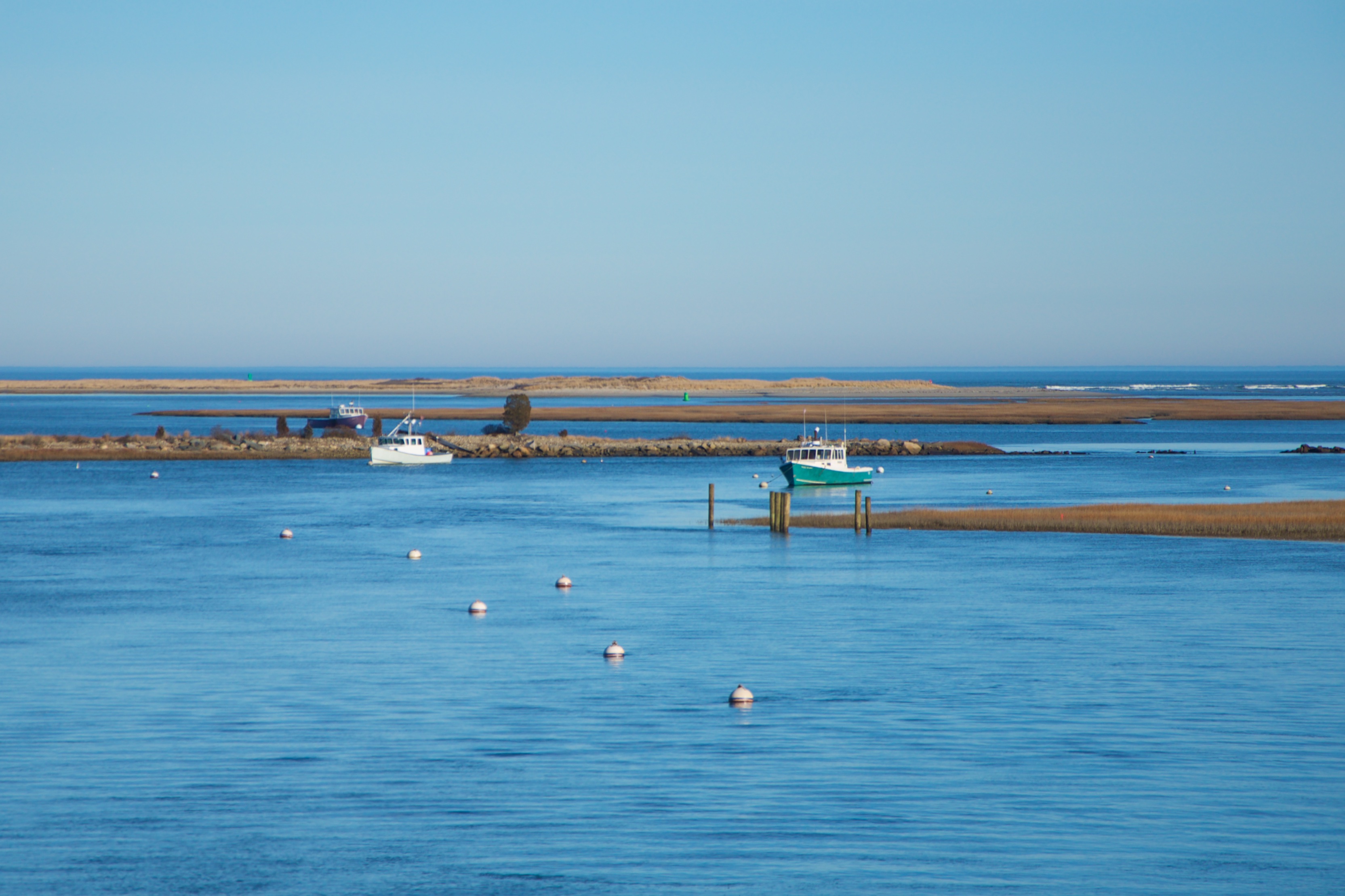
A summer time view of the North River looking east, as seen from the Route 3A bridge connecting Scituate and Marshfield:

A chart of the North River’s mouth and the large area of tidal flats. The exposed area that can be accessed is the green shaded area labeled “New Inlet” referring to its newly opened status since the Portland Gale:

Scituate Chart

Source: NOAA Nautical Chart. See disclaimer at NOAA.gov

The spit is typically visited by hundreds of boaters on an average summer afternoon. One must take great caution in bringing a boat into this area due to the swift current caused by the large volume of water discharging from the North River. By comparison, Bassings Beach in Cohasset, just a few miles to the north is a tie up for boaters that has a less severe current and more space. The Spit has been the target of several police crackdowns aimed at curbing noise and intoxication for which parties on the spit have become notorious.

Access to the spit can be obtained by boat (the easiest way) or by walking from the Driftway onto the access point near Moorland Road on Third Cliff. When attempting to access by land, it is best to go just before low tide, and carefully watch the incoming tide and the swift currents of the river.

Posted in Boston Harbor Day Boat Trips, Boston Harbor in the Winter, Uncategorized | Tagged , , , , , | Comments Off on The Spit at the North River’s Mouth

Historic Place of the week: Gloucester’s White-Ellery House

As one of the oldest structures in Massachusetts, The White-Ellery House stands as a relic of Gloucester’s colonial times:

gloucester

With its protruding, rocky coastline, Cape Ann was naturally spotted early on by European Settlers sailing from the East. Captain John Smith was the first confirmed European to spot Cape Ann in 1614, giving the name “Turk’s Head” to the three small islands-Thacher, Milk and Straitsmouth-lying just offshore. The first settlement on Gloucester occurred in 1623, pre-dating Salem by three years.

Built in 1710, The White-Ellery house was located near what was Gloucester’s town center. The house is named for the Reverend John White, the first owner of the house and minister of Gloucester, as well as Captain William Ellery, who purchased the house in 1740. While the site of the original 1623 settlement of Cape Ann was near Stage Fort Park in Gloucester Harbor, the permanent town center where the White-Ellery house is located was later built on the Eastern bank of the Annisquam river near some marsh lands. This area is close to the present day Grant’s Circle, and the bascule bridge which facilitates the train’s crossing of the Annisquam into Cape Ann. The bridge is pictured below:

annisquam river

As a major Massachusetts settlement, early Gloucester thrived on its fishing and ocean access. Perhaps most notable was the lighthouses of Thacher Island, which were built in 1771 and used as an aid to navigation for ships approaching Boston Harbor from the Canadian Maritime Provinces or Europe. At first controversial as colonists believed the lights provided more aid to the British than any colonial ship, the lights became subsequently relied on for centuries of mariners approaching Boston. It is said that not long after leaving sight of Sable Island and the South of Nova Scotia, The Twin Lights of Thacher Island and Highland Light in Truro would come into view.

The White-Ellery House on a snowy winter day:

gloucester

Posted in Boston Harbor in the Winter, historical place of the week | Tagged , , , | Comments Off on Historic Place of the week: Gloucester’s White-Ellery House

Winter on Cape Cod

Cape Cod in the Winter: The crowds and traffic are gone, leaving the sandy beaches wide open. The tall eel grass has turned yellow and blows in the wind. The temperature is often a bit warmer than that on the mainland due to the surrounding gulf stream waters.

Below are some photos of places on the cape including Nauset, Chatham, Monomoy Island and Sandy Neck taken during the course of the winter. Chatham’s Lighthouse has a bright and highly visible lens and located at the southeastern side of the town off Main Street. Further south, at the end of Tisquantum Road is the mainland-accessible portion of the Monomoy National Wildlife Area. This area contains some walking trails overlooking Monomoy Island to the south. Finally, Sandy Neck is a long stretch of dunes located on the north side of the town of Barnstable, on the Cape Cod Bay side. It has a large parking lot and its accessible off Route 6A.

Chatham Light up close:

Chatham beach:
Cape Cod

Chatham dunes looking East:

cape cod

Scrub pine on Chatham dunes:

Cape Cod

Distant view of Monomoy Island:

chatham

Monomoy through the birch trees:

cape cod

Chatham Light station:

Cape Cod

Sandy neck in Barnstable:

Barnstable

The dunes of Sandy Neck:

barnstable cape cod

A distant view of Scusset Beach, Cape Cod Power Station and the Sagamore Bridge from Sandy Neck in Barnstable:

Power

Sandy neck lighthouse in Barnstable (note holiday decor):

cape cod

Nauset Light flashing red:

nauset light

Nauset inlet:

cape cod

Highland light in North Truro:

lighthouse

Posted in Boston Harbor in the Winter, good views, Uncategorized, Weather | Tagged , , , | Comments Off on Winter on Cape Cod

Coast Guard cutter passing the fish pier

The US Coast Guard Cutter Flying Fish (number 87346) passed the Boston Fish pier and recently on a cold dreary day:

boston fish pier

Posted in Uncategorized | Tagged , , , | Comments Off on Coast Guard cutter passing the fish pier

Views from the Hancock Tower Observatory

Standing 790 feet tall over Boston, the Hancock Tower is Boston’s tallest building. Its old top floor observatory, closed more than a decade ago, was one of the best places to take in the view of the city and harbor from far above. Here are a few photos taken around the year 2000 of the city of Boston from the Hancock Tower’s 60th floor observatory.

Boston

While the view has not changed much in the past decade, there are some notable structures that were not yet built in the photos, such as 33 Arch St, the high rise tower that was completed around 2005. Below is a photo of the view looking Northeast, with the Charles, The Hatch Shell and Storrow Drive clearly visible. In the distance, one can see the Zakim Bridge, under construction but not yet opened:

boston charles river

Looking Southeast there is a good view of the financial district, the South Station area, the harbor and Logan Airport. Some notable high rise buildings that exist today are not present, including 1 Lincoln St (completed 2013). and 280 Congress St (completed 2010).

boston harbor

A closer, zoomed in view of the South Station Area. Note the building that is now the Ritz-Carlton Hotel and Residences under construction in the foreground. One can clearly see the runways of Logan Airport across the harbor, and the town of Winthrop in the distance:

boston

Some folks look out the window at the observatory. Note the old informational panels about the USS Constitution, Paul Revere’s Historical Home, and Logan Airport among other things:

observatory

For more of my photos of Boston at the turn of the century (that is the 21st century, not the 20th- I wasn’t alive then!) check out some these shots of the central artery.

Posted in Boston Harbor History, good views, Uncategorized, Visiting Boston Harbor | Tagged , , | Comments Off on Views from the Hancock Tower Observatory

Historic Places: Chelsea Naval Hospital

Located on the banks of the Mystic River in Chelsea, Ma, the Chelsea Naval Hospital is a more obscure and lesser know part of Massachusetts maritime history. Opened in 1836 for the treatment of naval personnel, the expansive 88-acre property treated members of the United States Navy throughout the wars and conflicts of the 19th and 20th centuries. The photo below is of the commanding officers quarters on the campus. Note it close proximity to the Mystic River (Tobin) Bridge.

Boston Harbor Historical Place

Among the hospital’s more famous patients were Presidents John Quincy Adams and John F. Kennedy. The hospital was closed in 1974, and the buildings on the property were subsequently converted into condominiums. The excess land was converted into a park, known today as the Mary O’Malley park.  The photo below is a view of the ground of the naval hospital as seen from the inner Boston Harbor:

Naval Hospital

A view from the grounds of the Naval Hospital: Positioned on the Mystic River, the park offers and good view of the Tobin Bridge and the Boston City Skyline. Across the river, there is a large dock which accommodates some of the largest ships coming into the inner harbor. It is here that a small body of water called the island end river extends inland from the Mystic- it accommodates a the Admiral’s Hill Marina. Note the granite blocks in the foreground which solidify the structure of the waterfront park. They are similar to those used in the construction of the main hospital buildings.

boston harbor

Access to the park is through Commandants Way in Chelsea, which is off the first exit northbound from Route 1.

Posted in Boston Harbor History, Boston Harbor in the Winter, historical place of the week, Uncategorized | Tagged , , , , , | 9 Comments

Ultonia Ledge, Thieves Ledge and the Dredging of Nantasket Roads

It was a warm summer day in the City of Boston, August 5th of 1899, when the Steam Ship Ultonia hit a ledge in Boston harbor, an event which likely spurred a major investment in Boston Harbor’s Shipping Channels. 

The late 1890’s was a time that the volume of transatlantic overseas passenger shipping and trade of raw goods was booming: While the city of Boston was subject to increasing prominence in global trade due to its coastal location, it was challenged to accommodate this new class of powerful deep-draft steamers which began making the journey from England. While the first steam ships had made transatlantic journeys in the earlier part of the 19th century, these new heavy and powerful twin-screw steamers like Ultonia could make the journey in only eight days. The Ultonia was a Liverpool-based Cunard steamer that made the journey from England to Boston weekly starting in 1898. It was a predecessor to some of its larger and better known Cunard Line steamers such as Carpathia and Lusitania. While leaving Boston for Liverpool on the 5th of August, 1899, the Ultonia’s hull hit a ledge on the ocean’s floor roughly a mile and a half southeast of Boston Light, while exiting the main channel at Nantasket Roads. This event prompted an urgent survey of the area for unknown rocks or wrecks, neither of which was found.

An undated photo of the Ultonia below, courtesy of ShipSpotting.com. For a full view, click on the photo below:

ShipSpotting.com
© Dulko

The conclusion was that Boston’s main shipping channel would have ideally been 35 feet deep at low tide, but it was far less deep in many places. At this time in our country’s history, before the outbreak of the first World War, or even the showcasing of America’s Great White Fleet the country seemed to be at a strategic inflection point with regards to shipping and trade: Would it stand up and make the necessary investment to become a port of great international prestige, or would it do nothing and take its chances at being limited in its ability to receive the newest largest ships? Surely this would be a challenge of economic ideals, as the harbor and its channels were the ideal “public good”- a piece of utilitarian infrastructure which many private interests were indeed interested in, but would not be able or willing to finance on their own! Fortunately, the US Congress was up to the job and in June 1902 approved a dredging plan which would deepen the harbor’s great Nantasket Roads channel to a depth of 35 feet at low tide, at a cost of nearly eight million dollars. But what was the catalyst for such a piece of legislation? I would make the case that it was at least in part this certain incident involving Ultonia: Our city was not about to jeopardize great potential economic gain over a shallow shoal or ledge.

The Ultonia Ledge, as it exists on nautical charts today was identified and spurred dredging activity that would ensure that the big ships would be safe in our harbor. As one can see on the chart, the Ultonia Ledge extends far East of Point Allerton and is as shallow as 21 feet. Ships exiting the harbor will now typically pass to the North of Thieves Ledge, observing the green marker, instead of passing to its south.

boston harbor

Source: NOAA Nautical Chart. See NOAA.gov for disclaimer.

Modern Day: Flash forward one hundred and fifteen years…..a light container ship exiting the harbor through Nantasket roads, as seen from the vicinity of Ultonia Ledge on a blustery November day. Smaller ships and vessels like the one pictured below will still use the Nantasket Roads exit. However, the largest, deepest drawing modern cruise ships, tankers and cargo ships will tend to use the wider and deeper President Roads Channel:

tanker in channel

Thieves Ledge: A bird crap-covered green buoy marking the Thieves Ledge, a marker outgoing vessels would steer to the south of prior to the Ultonia’s incident. (Note the Gloucester wind turbines visible in the distance).

boston harbor

The Ultonia was surely a meaningful (although obscure!) part of Boston Harbor’s history. The strange ledge was not economical to completely blast away given its large size and the availability of deep water elsewhere in the vicinity. The ship and its incident described above was surely an influencing factor in the development of our great port. As for the Ultonia, she continued service to Boston until 1906, then began serving ports in the Mediterranean. Unfortunately, she met her demise in 1917, when she was torpedoed by a  German U-Boat off the British Coast.

Sources:

“Hit Something”: Boston Daily Globe, August 6th, 1899
“Sweep Channel”: Boston Daily Globe, August 9th, 1899
“Buoy Placed to Warn Mariners Off”: Boston Daily Globe, August 15th, 1899

Posted in Boston Harbor History, Boston Harbor in the Winter, Boston Harbor Navigation, Uncategorized | Tagged , , , , , | Comments Off on Ultonia Ledge, Thieves Ledge and the Dredging of Nantasket Roads

The Urban Wild of Thompson Island

The view of Boston from Thompson Island, across a small span of Dorchester Bay:

boston harbor

Thompson Island is one of the closest and most accessible of the harbor islands. Located just across Dorchester Bay from the city of Boston, the island is accessible by a regular boat service in the summer months. Unlike the nearby urban island park that is Spectacle Island, Thompson is larger and is less oriented toward the tourist. Below is a view of an airplane landing over Spectacle Island on an autumn evening:

sunset

Thompson Island played a role in initial European settlement of Massachusetts, from its initial exploratory visit by Myles Standish in 1621 to its establishment of a trading post by David Thompson in 1626. The island had previously been settled by Native Americans who revered the place for its large rock outcrop, known as Chappel Rock or Squaw Rock (photos of this below). For a more thorough and complete historical overview, Thompsonisland.org has an excellent summary.

The island’s strategic location close to shore and the mouth of the Neponset river likely made it desirable to fishermen and traders. Today, the island can be relatively easily visited from Boston and Quincy: It serves as a summer camp and is open to the public on Sunday in season. And it is still a great place for fishing- especially near the mouth of the salt marsh on the Southeastern side. Pictured below, the drumlin on the Island’s north side gives perspective of Thompson’s relatively close proximity to the city of Boston:

thompson island

A view of Thompson Island and the city from North Squantum, a part of Quincy just south of where the Island is separated from the mainland by a narrow and shallow channel. The structure in the foreground is an old tower and Nickerson park.

reflection

Navigating around the island is relatively straightforward, with the exception of the island’s south side, which has a sand bar to shallow for most boats to pass. Additionally, the island’s East side, while secluded and calm is shallow and a bit rocky. The waters off the north side of the island, just west of Spectacle Island are some of the busiest and choppiest in the harbor given the converging currents.

The shores of Thompson Island are gradually sloping, especially those to the East: Tidal flat extend several hundred yards beyond the shoreline at low tide. Pictured below is a view looking east over Quincy Bay at Thompson’s flats near low tide:

Boston

An expansive inlet and salt marsh lies on the Southwestern side of Thompson Island. Such a secluded sanctuary for wild and aquatic life is rarely seen so close to the center of a major city. During summer months, the area of Dorchester Bay between this marsh and the nearby entrance to the Neponset River is teeming with minnows and porgies.

Boston Harbor

Some of Thompson Island’s indigenous residents: A big flock of turkeys! Look carefully and you will see them….In addition to turkeys and the usual squirrels and chipmunks, Thompson Island is said to be home to a population of deer, coyotes and skunks.

thompson island

A Blue Heron searches the water line around Thompson Island for a snack:

thompson island

Down on the farm: If you read about the complete history of Thompson Island in the links above, you would know that it was once a working farm. The remaining walls of what was once a working farm house on the island can be seen to this day:

farm

The main entrance to the old farm house is still fairly in tact. You can see an old photo of the farm as it used to look here, on the fbhi.org website. Today, the camp portion of the Island is full of several working structures including meeting space and lodging, in addition to two tall climbing structures (also part of the camp) that are visible from the mainland.

boston

Below is a photo of a man digging for clams (or treasure?) in the distance as dusk falls at low tide on a cloudy fall evening. The island’s remote and desolate feel stands in contrast to the bright lights of Dorchester and the Southeast Expressway just across the bay:

thompson island

Chappel Rock, also known as Squaw Rock: This is the point which separates Thompson Island from the mainland. At low tide, the large sand spit seen below is exposed:

thompson island

Among the many treasures of Quincy’s Thomas Crane Library is a photo of the spit and Thompson Island taken in June 1919. This photo is part of the library’s Samuel Warren Parker Collection. A view of the Long Island Bridge from Thompson’s grassy shores:

boston harbor

Looking west on a Gloomy Fall night, the illuminated JFK library in Boston comes into view to the west across the flat and still expanse of Dorchester Bay:

thompson island

A distant view of Thompson Island looking South from the top of the North Drumlin of Spectacle Island on a cloudy summer day:

spectacle island

A winter time view of Thompson Island in the foreground and the city of Boston in the background, as seen from the birch-lined forest of Quincy’s Nickerson State Park:

winter

The Thompson Island Ferry, against its namesake island, heading back to its dock at South Boston’s Reserved Channel on a late season fall day:

Boston harbor

Posted in Boston Harbor Day Boat Trips, Boston Harbor History, Boston Harbor in the Winter, Boston Harbor Navigation, Uncategorized | Tagged , , , , | Comments Off on The Urban Wild of Thompson Island

Green Harbor in the Winter

Marshfield’s Green Harbor is a year-round working harbor. It provides some of the best access from the Mainland (i.e. non-Cape) to Cape Cod Bay and Stellwagen Bank. This makes it an ideal spot for fishermen to access these waters year round. I visited Green Harbor only briefly this summer, but wrote a more detailed post at the end of last season.

Below is a photo of Green Harbor in the winter season:

Boston Harbor

The nearby Fire Control tower at Brant Rock: This structure was used in the World Wars but remains standing today, like the other towers of its type up the coast. It was near this place that the first two-way trans-atlantic radio transmission took place in 1906:

green harbor

Posted in Boston Harbor in the Winter, Boston Harbor Navigation | Tagged , , , | Comments Off on Green Harbor in the Winter

Storm Photos

The Nor’easter named “Hercules” hammered the Massachusetts coast last night and today. Here are a couple of views of this storm’s wrath from a couple of points south of Boston:

boston light

Nice day for a swim perhaps? That ocean spray feels very refreshing when the temperatures are in the single digits:

boston light

Some rough water around Georges Island, as seen from Hull:

storm

Minot light was cased in ice as the tall, raging waves broke against it on a day where the water was cold enough to stick to it. Here comes a big wave hitting the lighthouse:

Storm

boston

storm

scituate

cohasset storm

Today’s high tide at around noon at Cohasset Harbor. A little uncomfortably high I would say….the roads were blocked off in the area by police:

storm

Related Posts Plugin for WordPress, Blogger...
Posted in Boston Harbor History, Boston Harbor in the Winter, Uncategorized | Comments Off on Storm Photos