Safety, Fire and Rescue Boats in Boston

Sea Tow- one of the most important rescue boats on the harbor for recreational boaters:

With the weather turning colder and the seas getting rougher, it gets more dangerous to be out on the water. Fortunately, we have some pretty neat rescue and navigation equipment out on the harbor that can come to your need if you get in trouble.

Don’t forget to take precautions on your own including 1) keeping your equipment maintained, 2) keeping Coast Guard required safety equipment on board (lifejackets, flares, etc), 3) becoming a SeaTow or BoatUS tow member in case you break down, and 4) monitoring channel 16, the Coast Guard channel, while out on the water. Here are a few pictures I have taken out on the water of some of Boston’s fleet of rescue and safety craft. Above is a picture of one of Sea Tow’s vessels in Hingham Harbor.

Sea Tow rescue in progress:

Coast Guard Cruiser patrolling the inner harbor:

A smaller Coast Guard Patrol Boat keeps recreational boaters in line during a recent tall ships event. Check out the guns on this thing…you don’t want to mess with these guys!


Pilot boat escorting a larger boat out of the harbor:

Fire and rescue boat docked in East Boston: 

Boston’s police boats including the gray harbor patrol craft, which is, as us Bostonians would say, “wicked fast.” These are some of the most often used rescue boats on the Boston Harbor.


Posted in Boston Harbor Navigation, Visiting Boston Harbor | Tagged , , , , , , | Comments Off on Safety, Fire and Rescue Boats in Boston

More rough weather- heading out in breaking swells

Starting Friday night, and continuing into yesterday morning, the rain fell and the wind blew hard, kicking up some high nasty conditions out at sea. So naturally, I could not resist just going right out into the middle of it! I headed out Nantasket Roads and tried to get out as far as I could before the pounding surf sent me back in. Here is a video I took while navigating breaking swells of up to 8 feet just East of Allerton Point Saturday morning:

A check of wunderground.com showed that the 44013 buoy was reading 6 ft dominant wave height with a 5 to 6 second interval- so pretty big, tight chop. Since I had just written a bit about boating in the fall and the higher probability of encountering rough conditions, I thought I would put my advice to the test a little bit. I headed out Nantasket Roads and attempted to take the rough weather head on.

Once we got a bit beyond Boston Light, the swells started to break, which can be real trouble if they are big enough. I was looking back and saw a couple guys in a 26 foot Regulator appear and dissappear in the big swells- they finally called it quits and headed back. My 28 foot Whaler was handling it well, so we ventured out a little further. After a wave of about 8 feet crested and started to break in front of me, I had second thoughts. (I didn’t get to film this one as I had to keep two hands on the wheel). The way up was fine, but on the backside, the boat dipped hard…..almost buried the bow platform. I decided to turn around, but you can’t just turn a boat in breaking swells like these: get caught by one broadside and you could get flipped! So I waited for until I was on top of a well, and cut hard to the starboard, making sure the next one hit my stern at no more than 45 degrees.

I headed back in and ended up fishing around the marker at Sunken Ledge just to the Southwest of Peddocks Island. I had no luck fishing, but it was a lot more pleasant than being out in those breakers outside the Harbor.

Posted in Boston Harbor Navigation, Uncategorized, Weather | Tagged , , , | Comments Off on More rough weather- heading out in breaking swells

Channel dredging in Boston Harbor

Dredging is currently taking place in Boston Harbor to maintain the shipping channel near its narrowest point off Castle Island. This seems to occur every three to four years. Since several rivers flow into Boston Harbor -The Charles, Mystic, and Neponset to name a few- a great amount of sediment flows into the harbor over time. This can build up and create underwater obstructions that could damage the hull of a ship, or at least get it stuck. This problem can be fixed via dredging- a process of basically shoveling underwater rocks and muck out of the channel to keep it deep and wide. If you pass by Castle Island, you will likely see a barge with the big yellow crane pulling up rocks and muck off the bottom. Sometimes a tug boat comes along to move the barge around.

Buildup of sediment is a particular problem with the Mississippi River, which as a strategic port, needs to be dredged regularly given all the flow from the great plains watershed ends up in it.

Here is a chart clip of the general area being dredged- the end of the inner harbor and the start of the outer harbor. As you can see, the channel is very narrow in these areas, and depths of less than 10 feet occur just a short distance from the edge of the channel- especially on the South side near Castle Island. In order to safely accommodate cruise ship and cargo ship traffic, these channels need to be kept wide, and at a depth of generally at least 40 feet. Remember to be careful when boating in this area due to these dangers- see our post about the dangers of Boston Harbor for more details!

The chart images contained herein were obtained by the NOAA and are being used in accordance with their terms of permitted use. Altered and redistributed charts such as those shown below should not be relied on for navigational purposes. Please download the full version from “www.charts.noaa.gov” and please see terms of service at “http://www.charts.noaa.gov/RNCs/Agreement.shtml?13270
Posted in boston development, Boston Harbor Navigation, Boston Harborfront Development, Uncategorized | Tagged , , , , , | Comments Off on Channel dredging in Boston Harbor

Boston Harbor picture of the week: Sunrise over Hull

I took this sunrise photo recently on a clear morning aboard an early commuter boat into the city.  With the weather getting cooler, the humidity getting lower, and the sun rising later, this time of year is ideal to see good sunrises over Boston Harbor.

Posted in Boston Harbor Picture of the Week | Tagged , , | 1 Comment

Aerial views of Boston Harbor and its surroundings

I think one of the best ways to view the coastline is from the aerial perspective. Around Boston, most flights in and out of Logan Airport send you right over the coast, so you can get a unique perspective of where things are. Of particular interest to me is seeing how shallow the harbor looks from the air (just after takeoff, you can see the obstructions lying below the water around Castle Island). Also of interest is how amazingly close Provincetown and Gloucester look to Boston when you see them from the air. Above is a photo taken while on descent just East of Boston, as the jet was making a loop to the South of the city. Of particular note here is South Boston, and the lagoon, i.e. “sugar bowl” around Castle Island.

Quincy. Here is a photo from the same flight (above) as the plane makes a loop over the South of Quincy, Ma. If you follow the Neponset River to the North, you can see Route 3, Marina Bay, and U-Mass Boston and the JFK Library in the distance.


North Shore: Here is a great aerial view of Gloucester while heading South near Boston. You can see Gloucester Harbor, the Cut up the Annisquam River and the 128 Bridge, then all the way up to the sandy spit and marshes of Essex and Ipswich to the North.

Lower resolution, but broader view:

Nahant and the North Shore:

Nahant

South of Boston: Scituate Harbor, the North River and Duxbury Beach/Plymouth Harbor in the distance:

Scituate

Chatham Harbor & Monomoy Island: I took this while heading South out of Boston. It is a winter shot, but still kind of a neat perspective on the ever-changing shoals of Chatham Harbor.


Nantucket. Here is an aerial view from a small propeller plane of Nantucket Harbor while heading down the to Island in Winter. Check out Brandt Point and the Boat Basin:


Coastal Maine. Here is an aerial view of the rocky outcrops of the Maine Coast, taken while starting decent into Boston after a trans-Atlantic flight. This is the area just North of Casco Bay, in between Casco and Penobscot. In the foreground is Pemaquid Point and Muscongus Bay, toward the center-left, Boothbay Harbor can be seen, and to the far left, you can make out the Brunswick Naval Air Station at the top of Casco Bay.

A sunset view of South Boston while on final approach to Logan:

logan approach

Posted in boston development, Boston Harbor Day Boat Trips, Boston Harbor History, Boston Harbor in the Winter, Boston Harbor Picture of the Week, boston local issues, Uncategorized, Visiting Boston Harbor, Weather | Tagged , , , , , | 1 Comment

Fall boating: A higher probability of encountering rough seas.

Fall in New England means changing weather fronts and the greater possibility of rough seas. On the Massachusetts coast, rough seas often are the result of an Easterly wind. The larger wind fetch of the open ocean to the east results in larger waves and more rough seas than on days when the wind comes from the West or Southwest.

In the area of Massachusetts Bay outside Boston Harbor and to the South, we are well protected by Cape Cod. Normal days with convection-generated Southwest winds, this land mass to our South and Southwest protects agains a long wind fetch. Boaters in Rhode Island, Connecticut and even Buzzards Bay know that the boating can get very rough, even on a fair weather afternoon due to the long southwesterly  wind fetch over Long Island Sound and the Block Island area. But in Boston, it’s the Northeast and Eastern exposures that tend to kick up the roughest seas. Here are a few considerations if you are heading out in less than ideal conditions:

1) Check the marine weather forecast at wunderground.com. A series of buoys along the coast can give you real time data on wind speed and wave height. The closest station to the open waters outside Boston Harbor is the 44013 Buoy, which is very useful to monitor.

2) A general rule of thumb is that if the wind speed in kts is higher than the length of your boat in feet, stay in. But don’t push your luck on this one! Here are a few more potentially  helpful bits of advice for boating in rough seas:

3) Go slow. Most obviously, this results in a smoother ride with less pounding. Rough seas also negatively impact fuel economy, so the slowest speed you can achieve while getting the boat to plane may be optimal.

4) Quarter the waves. This means approaching at a 45 degree angle. Approaching head-on will be rough and innefficient, leading to poor fuel economy. Riding parallel to the waves subjects your boat to potentially dangerous roll.

5) Use trim tabs to keep the bow down in an oncoming sea, and when quartering, trim up the side hitting the waves. This results in more comfort and stability as the “V” of the hull will be hitting the waves straight on, instead of having the underside pound flatly against the water. Given that we just saw the olympics, here is a diving analogy: Putting your V-hull head on into the chop is the boating equivalent of diving- pounding flat against the underside is like a belly-flop. The former is smooth, the latter?….ouch.

6) Be careful of following seas. If you go out to see in head on chop, you will experience a following sea when you return (unless the wind changes completely when you are out). A following sea is more pleasant, but be careful not to bury the bow. Too much trim tab usage can be dangerous here- I usually don’t use them at all in a following sea. Boats with narrow beams can be especially tricky here, as they tend to dig in more.

Finally, here is a good link from Boatsafe about handling your boat in rough seas:

http://www.boatsafe.com/nauticalknowhow/waves.htm

Below are a couple of videos I have taken while boating in some rough seas. The first is in Massachusetts bay while approaching Provincetown (seen in distance) in large but smooth rollers. The second is while returning from fishing on a rough day in a following seas while several miles East of Boston Harbor. The roughness of the sea is not greatly visible in these videos, although the technic for keeping the ride smooth should be:


Posted in Boston Harbor in the Winter, Boston Harbor Navigation, Fishing, Uncategorized, Visiting Boston Harbor, Weather | Tagged , , , , , , | Comments Off on Fall boating: A higher probability of encountering rough seas.

Mega-yachts in Boston Harbor

Could it be our attractive city nightlife and culture? Or is just an accessible deep water port in the center of our financial district? I’m not sure what it is, but recently, Boston has attracted its fare share of Mega-yachts that have been tying up at the docks near Fan Pier and Rowes Wharf. Perhaps it is just a sign of the times.  These are not just Yachts- they are truly floating mansions, equipped with multiples rooms, a full crew, tenders that are often >25 ft long- even some with a pool or helicopter pad.

The Boston Harbor waterfront provides a phenomenal place to tie up given the beauty of the Rowes Wharf complex and nearby rotunda at the Boston Harbor Hotel. Many days this summer, several Megayachts could be visible tied up in front of this area. It gives the Boston city skyline a pretty cool look.

Here is one of the particularly large yachts that is currently anchored in front of Fan Pier. I observed here coming up the coast from Cohasset on Monday. She is the Exellence V- I’m not sure that this Yacht is privately owned- it may be part of a charter company. But it is rentable for the week (see the website here)….its a bit out of my price range!

The marinas at both Fan Pier and Rowes Wharf are capable of holding Mega-Yachts, which is great, since the presence of these yachts is visually and likey economically additive to the city of Boston.


Posted in boston development, Boston Harbor Navigation, Boston Harborfront Development, Uncategorized, Visiting Boston Harbor | Tagged , , , , , | 2 Comments

Hurricane season on Boston Harbor: getting prepared

Its that time of year again….Hurricane season! With Hurricane Isaac in the news this week, Boaters will likely have the possibility of hurricanes on their mind for the remainder of the boating season (which still has a good two months left as I write this). Last year, hurricane Irene briefly threatened the Boston Harbor area, but its course veered to the West, resulting in the storm making landfall as a category 1 storm near New York City. Had the storm veered about 100 miles further East, we probably would have had more of a problem. I remember spending just about the entire day on my boat monitoring the hurricane. The damage at the marina was minimal, but in nearby Dorchester Bay, several sailboats moorings were pulled loose, and they washed up on the beach in South Boston near Castle Island. Above is a picture I took of the aftermath. Below is a picture I took of some docks at my marina which were blown out of the water due to strong hurricane force winds.

Here are some hurricane safety considerations for boaters:

First off, I would like to highlight an excellent and comprehensive hurricane preparation guide from BoatUS. This can be accessed here. Boaters should refer to this for complete and official hurricane preparation advice.

Much of the outcome of a hurricane on your boat will be dependent on the characteristics of the Marina you are docked at. Some of the most important factors determining the outcome of a hurricane are the height of the pilings securing the dock, and the number of sides on which the marina is surrounded by land. The higher the pilings, the lower the risk that the docks could rise above the pilings in a storm surge and become dislodged. In terms of surroundings by land, a marina that is surrounded by land on three sides, such as Hingham Shipyard Marina, will generally fare much better in a storm than a marina with land on just one side, as the wind fetch at most angles is minimized when the marina is surrounded by land.

In the Boston Harbor area, Hingham Shipyard Marina, Marina Bay, and the Town River Marina in Quincy all stack up very favorably on these measures. Other marinas may as well-these are just the ones that I am familiar with. Below is an example of the Hingham Shipyard Marina, where I tie up this season. Due to its surroundings by land on most sides, the marina is well protected from long wind fetches, with the exception of a little bit of fetch to the NE.


Ideally, pilings will be tall enough to hold the dock even in the event of a storm surge coinciding with high tide. These pilings below look quite adequately high:


The best and safest option to avoid damage from a hurricane is obviously to haul the boat and store it on land. However, this may be impractical and expensive, and could put an early end you your season. Boaters should monitor the direction and strength of the hurricane to assess whether hauling is the best option. In the case of a strong storm making direct landfall on your area, Hauling certainly is the best option. In a case where you don’t haul, consider the following:

If on a mooring, your boat may be more exposed, but in this position there may be fewer objects or other boats that could collide with your boat. Check the type of mooring you have and its scope. BoatUS recommends scope of greater than 3 to 1 to improve strength. Boaters should remember that during a storm surge, the higher water will result in a lower scope.

On a slip, it is imperative to secure boats thoroughly- BoatUS recommends use of eight lines. Another very important consideration is to remove canvases and curtains- anything that creates drag- as these things could act as sails in strong hurricane force winds, thereby increasing wind pressure on the dock. I witnessed this directly last year, when a large boat with a canvas top up created enough drag to buckle the dock and nearly pull it off its pilings. Were it not for the excellent and fast response from the marina staff and Environmental Police, there could have been extensive damage:

Good luck out there- hopefully hurricane season does not impact Boston Harbor, but if it does, hopefully this will help keep you and your boat safe!


Posted in Boston Harbor Navigation, Weather | Tagged , , , , , , | Comments Off on Hurricane season on Boston Harbor: getting prepared

Boston Harbor to Provincetown Day Trip

Provincetown, Massachusetts on Cape Cod makes a great day trip or overnight trip from Boston Harbor- provided you have good weather, patience and a large enough boat to handle the open water. The latter consideration is really the captain’s call as to what constitutes large enough. In my previous boat, a 19 foot center console, I was not confident enough to make the trip all the way across to Provincetown. With the 28′ I have more than enough confidence to bring the entire family.

I set out for Provincetown yesterday in the early afternoon. We had not yet made the trip down this season, so a day trip was in order. Yesterday (8/29) was a perfect day – land weather wise. Sea weather? not so much. With the cold front that brought in this deep blue sky, cooler temperatures and dry, crisp air came a hard wind out of the Northeast that kicked up some five foot swells. Luckily, the wind action was largely in the morning, and, as typically happens as a front moves through, winds die down throughout the day. Tightly spaced white caps relax into long, drawn out swells as if someone had taken a rolling pin to them and pushed them out. The latter is much easier to navigate in.

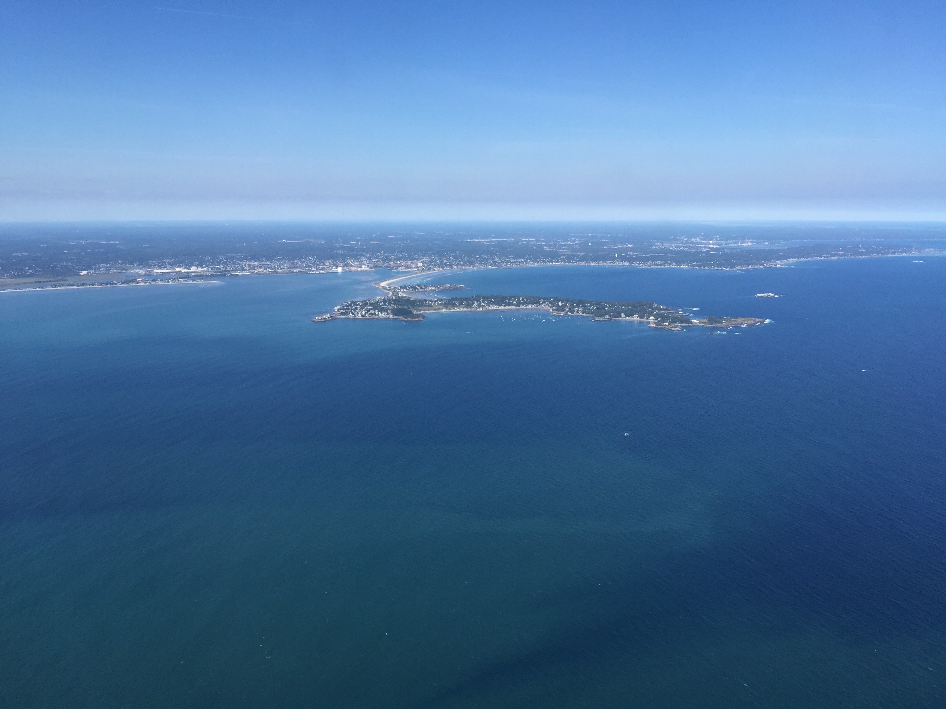
I left Point Allerton in Hull at 12:45 PM and was in Provincetown Harbor by 2:30 PM. This is a decent trip time given the rough seas. At one point, about five miles off Race Point in very open water, the swells got big enough that I had to pull up the trim tabs fully to keep the boat from burying the bow and listing. Quartering big swells can be very effective if you do it right and don’t go too fast. From Allerton Point, I placed a waypoint on Race Point at Provicetown, and made a route from there. This route had me passing Minot light within 15 minutes, and being due East of the Scituate Driftway ten minutes after that (the Driftway is now easy to spot with the huge new windmill). There is about another 20 minutes from here when all one can see is the Scituate/Marshfield coast behind them until the Standish Monument at Provincetown emerges from the horizon. On most days, a boater will not lose sight of land during this trip.

Below is a visual of my GPS with my position as  I approached Race Point. As you can see, I deviated to the SE of my course due to heavy seas:

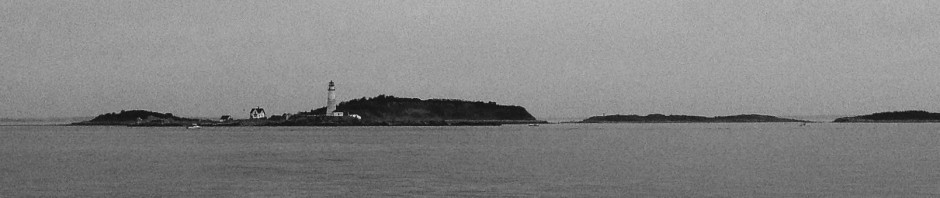
Rounding Long Point, with the lighthouse in the background:

When we got to Provincetown, I called Flyer’s ,which operates the mooring field. Because we were only tying up for a few hours, this was a better option than a transient slip (which we did last year when we were staying overnight). Flyer’s charges $20 for a mooring for the day- I think this is a great deal if you don’t need water and power at a slip. For those looking to stay overnight, I would recommend the Provincetown Marina.

Successfully tied onto a mooring on Provincetown Harbor:


View from the pier at Flyer’s:

 The bike trail through the Provincelands, where one can bike through secluded sandy dunes, with a spectacular distant ocean view in three directions:

A blue sky day reflected well behind the downtown Provincetown landscape:

We stayed in Provincetown for a late lunch and some shopping- all in about 3.5 hours. It is such a cool town to hang out in, as there is something for everyone. For boaters, the waters around Provicetown are ideal, as they are so protected in virtually every direction. We headed back around 6:00 PM so that we could be back in familiar Boston Harbor waters by dark, which came around 8:00 PM.

Heading outbound, back around Long Point, passing Wood End and heading East:

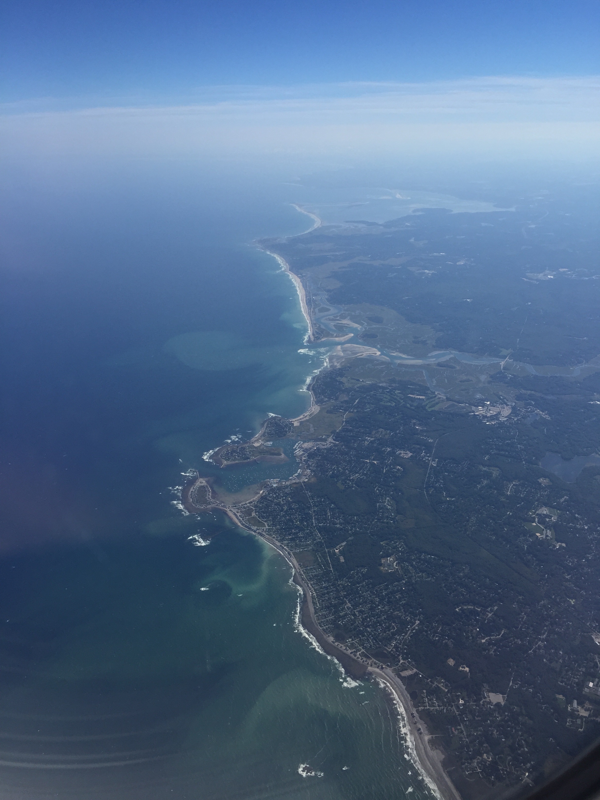
Heading out of Provincetown Harbor, one Navigates at first to the South to get around Long Point, and then to the SouthWest to get around Wood End. While on the latter bearing, one can see the Hills of Plymouth, MA  directly to the East on most clear days. Last night was so clear that we could also see the big smoke stack from the power plant at Scusset Beach to the South East, and the windmills off Route 3 in Plymouth quite clearly. Soon after, the lookout tower at Brant Rock in Southern Marshfield became visible.

The trip home was awesome. We had much calmer seas than on the way out, and great views. We could see the sun setting behind the Boston Skyline off the bow, and a nearly full moon rising out of a deep purple haze to the stern as we passed Minot Light:


If you are thinking of making this trip, feel free to contact us for any advice or further details that may be helpful. Of course, for folks who don’t have their own boat, there are two companies operating high speed ferry service between Boston and Provincetown. These trips usually take 90 minutes.

Here are some additional photos from last year’s Provincetown Trip:

Last year, I docked at the town pier, instead of sitting on a mooring at Flyers’s. Here was the view of the downtown from the pier in the early morning:

All the boats docked up on a warm Saturday afternoon in mid summer:

Another view of the town pier, looking across the channel:


Posted in Boston Harbor Day Boat Trips, Boston Harbor Navigation, Visiting Boston Harbor | Tagged , , , , , , , , , , | Comments Off on Boston Harbor to Provincetown Day Trip

The Brewsters: Great & Little Brewster Island and Boston Light

The Brewsters, comprising Great Brewster and Little Brewster Island, are ideally visited in the early spring and late summer/fall months when the massive flocks aggressive gulls are not nesting. Logistically, the islands are challenging to visit due to their limited public access points and far distance from downtown Boston. 

Named for William Brewster, the preacher of the Plymouth Colony and an original Mayflower passenger, these islands are some of the outermost in the Boston Harbor. They are also some of the most rocky and dangerous. As mentioned in previous posts, Boston Light, which is located here on Little Brewster, is the only fully manned lighthouse in operation on the East Coast. The light was originally created in the year 1716 to warn sailors of the treacherous waters near the Harbor’s entrance. The  original structure was burned down by the British out of spite as they evacuated Boston Harbor in March 1776. Today, equipped with its original fresnel lens, the light is one of the most powerful in New England, easily visible from East of Cape Ann.

boston harbor

Positioned at the end of the rocky outcrop of Little Brewster Island, you can visit the lighthouse and the nearby Coast Guard Station, and take a guided tour- check out this link for more information about how to get involved:

boston light

 One can see how this location was chosen for a lighthouse given its proximity to the Nantasket Roads Channel, and the treacherous nearby rocks. Below is a view of the lighthouse looking East on a bright blue autumn day:

boston harbor

Just East of Little Brewster Island are some rock outcrops called the Shag Rocks, named for the Shag- a species of bird which inhabits the rocks. Below is a view of the Shag Rocks looking west:

boston

Great Brewster Island: Nearby Great Brewster Island is a much larger island with a large sand dune on its northeastern shore. This island is not accessible by public transportation, but can be accessed by private boat. The walk to the crest of the dune provides a stunning view to the East of Boston light and the Atlantic Ocean.

boston harbor

I like to call Great Brewster the “Wild Island” due to its undisturbed natural state of windswept dunes, overgrowth of wildflowers and sumac, and inhabiting creatures not used to seeing humans. I have accessed this island by throwing an anchor just west of Great Brewster and swimming to shore. If you decide to visit this island, beware of the Seagulls. They use this island to nest and are tend to become quite aggressive toward humans in spring and early summer!

Great Brewster and Little Brewster, as seen from Deer Island on a windy winter day:

boston harbor islands

A great mistake mariners make around these Islands is to cut across the Brewster spit, which extends probably a quarter mile at least to the west of Great Brewster Island, to a rocky outcrop of a ledge, pictured below. In what is a deceptively calm and open stretch of water, the sandbar is fully submerged near high tide and most any boat trying to cross it will run aground. As previously mentioned, I have seen boats stranded on the Brewster Island Spit, and it is not a fun experience for those involved given the high visibility and rough nearby waters of Nantasket Roads. This spit makes our list of the dangers of Boston Harbor, which I would encourage boaters to use caution around.

A section of the spit at low tide, looking north, with Salem visible in the background:

boston harbor

The Brewster Islands as seen from the top of Fort Standish on Lovells Island:

boston

Below is a photo of the waters near the spit (between the rocks and the lighthouse) at high tide. Notice the spit is not visible, but it is there- right below the water!

spit

Sailing out by the Brewsters:

sailing

Related Posts Plugin for WordPress, Blogger...
Posted in Boston Harbor Cruises, Boston Harbor Day Boat Trips, Boston Harbor Navigation, Visiting Boston Harbor | Tagged , , , , , | Comments Off on The Brewsters: Great & Little Brewster Island and Boston Light